
Jelutong Travel Guide
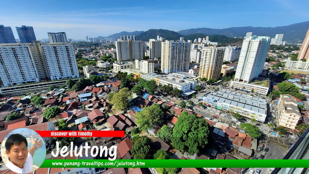 Jelutong Travel Guide (22 January 2022)

Also available: Panduan Melawat Jelutong
Jelutong (Chinese: 日落洞; Pinyin: Rìluòdòng; Penang Hokkien: Jit3-lor3-tong) is a densely populated residential suburb on the southeastern side of Penang Island, south of the centre of George Town. Historically associated with working-class households, small businesses and coastal livelihoods, Jelutong has developed into an established urban neighbourhood with traditional shoplots, markets, places of worship, residential flats and newer high-rise buildings.
Quick Facts
- Place name: Jelutong (日落洞)
- Location: Penang Island, Penang, Malaysia
- Administrative area: George Town and its surrounding urban area
- Approximate coordinates: 5.38951°N, 100.31298°E
- Character: Established residential and commercial suburb
- Main road: Jalan Jelutong
- Nearby coastal route: Tun Dr Lim Chong Eu Expressway
- Local landmarks: Jelutong Market, Jalan Jelutong and Masjid Jamek Jelutong
- Historical livelihoods: Small-scale commerce and coastal activities, including charcoal making in some areas
- Getting around: Local buses, car, motorcycle, taxi and e-hailing services
Geography and Location of Jelutong
Jelutong lies on the eastern side of Penang Island, south of central George Town. It forms part of the continuous urban area extending from the city centre towards Gelugor and the southern districts of the island. Its landscape is predominantly built-up, with residential streets, commercial premises, community facilities and roads linking the neighbourhood to other parts of George Town.
Jalan Jelutong is the principal local thoroughfare and an important reference point for the area. The road connects neighbourhoods to the north and south, while smaller roads provide access to residential communities, shops, markets and places of worship. In general terms, the older neighbourhood is often described as East Jelutong and West Jelutong, referring to the areas on the seaward and landward sides of Jalan Jelutong respectively.
The coastline has changed substantially as the city expanded. The Tun Dr Lim Chong Eu Expressway runs along the eastern side of the island and provides a major route for traffic travelling between central George Town and the southern part of Penang Island. Coastal development and land reclamation have also altered the relationship between the older settlement and the shoreline.
Distance from Jelutong to Major Destinations
Using the junction of Jalan Jelutong, Jalan Tan Sri Teh Ewe Lim and Jalan Ahmad Nor as a reference point, the approximate road distances are:
- Komtar: 4.2 km
- Penang Bridge: approximately 4.2 km to the bridge approach area, depending on the route used
- Second Penang Bridge: approximately 12.2 km to the approach area, depending on the route used
- Penang International Airport: approximately 12.7 km
These are indicative distances rather than guaranteed travel distances or times. The actual journey depends on the starting point within Jelutong, the destination entrance and the route taken. Traffic can be heavy during peak commuting periods.
History of Jelutong
Jelutong developed as George Town expanded beyond its older urban core. By the turn of the 20th century, population growth and the spread of settlement southwards were contributing to the development of neighbourhoods outside the original town centre. Jalan Jelutong gradually became an important route through this growing settlement.
Older accounts describe parts of Jelutong as a relatively undeveloped coastal area compared with central George Town. Before the extensive urbanisation of the shoreline, sections of the coast contained mangroves and other wetland environments. Residents in some coastal localities earned a living from activities such as charcoal production, which made use of mangrove wood. Lebuh Bakau and its surroundings are associated with this aspect of Jelutong's past, although the extent and timing of the decline of charcoal making varied by locality.
Over the decades, road improvements, population growth and changes in land use transformed Jelutong. Low-rise housing, traditional shoplots and small businesses came to form part of the established urban landscape. From the latter part of the 20th century, apartment blocks and other higher-density housing added to the area's residential capacity. Newer residential developments have continued to change parts of the neighbourhood.
Jelutong has also been associated historically with working-class households and small-scale businesses. Older descriptions sometimes refer to social problems such as gangsterism during the 1970s. Such accounts should be understood in their historical context rather than treated as a description of present-day residents. Jelutong today is a varied urban neighbourhood whose character is shaped by homes, businesses, transport links and community institutions.
Origin of the Name Jelutong
The neighbourhood's name is commonly associated with the jelutong tree, Dyera costulata, a large tropical forest tree native to Peninsular Malaysia and other parts of Southeast Asia. The tree can grow to more than 60 metres in suitable natural conditions and produces a white latex. Its timber has been used for products such as pencils, carvings and other wooden items, while the latex was formerly used in chewing-gum production and other applications.1
The association between the place name and the tree is widely repeated, but a detailed historical account identifying the precise origin of the neighbourhood's name is not readily established by the general references available. The name alone does not prove where or how many jelutong trees once grew in the settlement. The tree is not a defining feature of the present-day built-up suburb, and visitors should not expect to find a stand of jelutong trees simply by visiting the neighbourhood.
Neighbourhoods and Local Landmarks
Jalan Jelutong
Jalan Jelutong is the main road associated with the neighbourhood. Along and around it are shops, food businesses, housing, service premises and local traffic connections. The road is useful for orientation, but its commercial sections can be busy, particularly where vehicles stop to access shops and market facilities.
Jelutong Market
Jelutong Market is one of the neighbourhood's familiar community landmarks. Wet markets in Penang typically serve nearby residents with fresh produce, meat, seafood and other everyday necessities; stalls and surrounding businesses may also provide prepared food. The market and its surrounding streets are part of the area's everyday commercial life rather than a purpose-built tourist attraction.
Traffic and parking can be challenging near the market, especially during busy shopping periods. Visitors who intend to browse the market should allow time to find parking or consider arriving by public transport or e-hailing where practical. Opening hours and the operating days of individual stalls should be checked locally.
Lebuh Bakau and the Coastal Past
The name Lebuh Bakau recalls the Malay word bakau, meaning mangrove. The locality is associated with Jelutong's former coastal environment and the history of charcoal making in parts of the area. The shoreline and its surroundings have changed through urban growth and infrastructure development, so the present-day landscape may look very different from the mangrove environment described in older accounts.
Places of Worship and Community Life
Jelutong is home to communities of different backgrounds and religious traditions. Masjid Jamek Jelutong serves the local Muslim community, while other places of worship and community facilities reflect the area's diverse population. These institutions are part of the neighbourhood's everyday life and provide useful reference points when navigating the surrounding streets.
What to See and Do in Jelutong
Jelutong is primarily a residential and commercial suburb, not a destination centred on major sightseeing attractions. Its interest for visitors lies in its local food, market activity, street life and the contrast between older neighbourhoods and more recent urban development.
- Visit Jelutong Market: Explore the local market and nearby shops to get a sense of everyday shopping and food culture.
- Explore Jalan Jelutong: Observe the mix of traditional commercial premises, housing and newer buildings along the main road.
- Look for local food: Seek out coffee shops, hawker stalls and neighbourhood eateries, whose offerings and opening hours vary.
- Learn about the old coastal landscape: Use the history of Lebuh Bakau and the former mangrove areas as a starting point for understanding how the shoreline has changed.
- Explore nearby George Town: Jelutong's location makes it possible to combine a local visit with the historic centre of George Town and other parts of Penang Island.
Visitors should remember that Jelutong is a lived-in neighbourhood. Residential lanes and community facilities are not necessarily visitor attractions, and photography should be respectful of residents' privacy.
Food in Jelutong
Food is one of the practical reasons to explore Jelutong. Its market area and commercial streets serve local residents, with food options typically including hawker fare, coffee shops, casual restaurants and small eateries. The range available at any particular time depends on the location and the businesses operating that day.
As in other parts of Penang, visitors may encounter Chinese, Malay and other Malaysian food traditions. Rather than relying on a fixed list of famous dishes or assuming that every outlet serves the same menu, it is best to explore the market surroundings and established commercial strips for currently operating stalls and restaurants.
Visitors seeking halal food should check the status of individual outlets rather than assuming that all food businesses in a mixed neighbourhood are halal-certified. Those with dietary restrictions or allergies should confirm ingredients directly with the vendor.
Where to Stay in Jelutong
Jelutong has residential apartments, condominiums and other housing, but it is not one of Penang's main hotel districts. Depending on availability, visitors may find short-term accommodation in or around the neighbourhood, including serviced apartments and privately managed units. The facilities, legal status and access arrangements of individual properties should be checked before booking.
For travellers who want a wider choice of hotels, central George Town offers accommodation across a range of categories and is a relatively short distance away. Visitors planning to spend much of their time in the heritage area may find it more convenient to stay there and visit Jelutong as a separate excursion. Travellers arriving by car should check whether their accommodation provides parking.
How to Get to Jelutong
By Car
Jelutong can be reached from central George Town by travelling south towards Jalan Jelutong. Drivers approaching from other parts of Penang Island can use the island's main road network and connect to the local roads serving the neighbourhood. The Tun Dr Lim Chong Eu Expressway provides a major coastal route, although access to individual parts of Jelutong depends on the intended destination and available junctions.
Allow extra time during morning and evening commuting periods and when travelling near the market. Although the expressway carries through traffic along the coast, local congestion can still occur on Jalan Jelutong and surrounding streets.
By Bus
Jelutong is served by Penang's public bus network, and buses travelling along or near Jalan Jelutong have historically connected the neighbourhood with other parts of the island. Routes, stopping points and service frequencies can change, so visitors should check the latest Rapid Penang information before travelling rather than relying solely on older route numbers.
When planning a bus journey, identify the stop closest to the intended destination in Jelutong and check whether the service operates at the desired time. Some parts of the neighbourhood may require an additional walk from the main road.
By Taxi or E-Hailing
Taxis and app-based e-hailing services offer a direct way to reach Jelutong from central George Town, the airport or other parts of Penang Island. They can be particularly useful when carrying luggage, visiting several locations or travelling to streets that are not close to a bus stop. Travel time varies according to traffic conditions.
Getting Around Jelutong
For most visitors, the most convenient way to move around Jelutong is by car, motorcycle, taxi or e-hailing service. Walking is practical for exploring a small area around the market or a particular commercial street, but the suburb is spread across busy roads and residential sections that may not be comfortable to cover entirely on foot.
Jalan Jelutong can experience slow traffic, particularly around busy commercial areas and the market. Vehicles stopping or parking along the road may reduce traffic flow. If driving, use designated parking areas where available and avoid blocking shop entrances, residential access points or pedestrian routes.
Cyclists and pedestrians should take care on major roads, where traffic volumes can be high. Before walking between destinations, check the route and distance rather than assuming that two nearby places on a map are connected by a convenient footpath.
Traffic and Urban Development
The development of the Tun Dr Lim Chong Eu Expressway has provided a route for through traffic along the coast, reducing the need for some journeys to pass through the older local road network. However, this has not removed congestion from Jelutong itself. The main road and the streets near busy commercial premises continue to carry local traffic, including vehicles making deliveries and accessing homes and shops.
Jelutong's location close to central George Town makes it attractive for people who need access to the city while living outside its historic core. At the same time, additional housing and continued urban activity can increase demand on roads, parking and community infrastructure. Conditions differ from one street to another, so traffic and accessibility should be assessed for the specific location being visited or considered for accommodation.
Practical Information for Visitors
- Best reason to visit: Local food, the market, everyday neighbourhood life and the history of urban development on Penang Island.
- Time needed: A short visit may be sufficient to explore the market and nearby commercial streets; allow longer if combining Jelutong with other parts of George Town.
- Transport: Check current bus routes and traffic conditions before setting out.
- Parking: Parking may be limited near busy market and commercial areas.
- Accommodation: Check the exact location and parking arrangements; central George Town has a broader choice of hotels.
- Respect for residents: Jelutong is a residential community, so be considerate when taking photographs or entering local streets.
 Map of Jelutong
 Hotels in Jelutong
- Avatel Jelutong (GPS: 5.40343, 100.318)

Amenities in Jelutong
- Jelutong Post Office (GPS: 5.38744, 100.31253)

Apartments, Condominiums and Flats in Jelutong
- 86 Avenue Residences (GPS: 5.40343, 100.318)

- Alton Skyvillas (GPS: 5.39266, 100.31624)
 planned
- Altus Soho (GPS: 5.39318, 100.31559)
 planned
- Artis 3 (GPS: 5.39318, 100.31559)

- Bukit Dumbar Indah (GPS: 5.38159, 100.31006)

- Bukit Dumbar Permai (GPS: 5.38032, 100.31016)

- Bukit Dumbar Residences (GPS: 5.38492, 100.31562)

- Bukit Dumbar Villa (GPS: 5.38135, 100.31186)

- Casa Impian (GPS: 5.39543, 100.31211)

- Central Park Condominium (GPS: 5.39543, 100.31211)

- Damai Vista (GPS: 5.39543, 100.31211)

- Desa Bukit Dumbar (GPS: 5.39543, 100.31211)

- Desa Green Block 5 (GPS: 5.39758, 100.3109)

- Desa Green (GPS: 5.39854, 100.3108)

- Desa Pinang, Bandar Sri Pinang (GPS: 5.40102, 100.32895)
 and (GPS: 5.40236, 100.3307)

- Desa Selatan (GPS: 5.40315, 100.32596)

- D'Mansion @ Dumbar Heights (GPS: 5.3866, 100.31279)

- Dumbar Villa (GPS: 5.3866, 100.31413)

- Eastern Court (GPS: 5.39658, 100.31028)

- Edge 360 (GPS: 5.38276, 100.31538)

- Flat Jelutong Indah (GPS: 5.38237, 100.31592)

- Grace Residence
 (GPS: 5.38981, 100.31709)

- Halaman Kristal (GPS: 5.40403, 100.31341)

- Harmony View (GPS: 5.39887, 100.31361)

- Jelutong Palace (GPS: 5.38829, 100.31439)

- Jelutong Park (GPS: 5.3878, 100.31604)

- Kobay Jelutong (GPS: 5.38921, 100.31541)
 (planned)
- Lavender Park (GPS: 5.38921, 100.31541)

- Medan Hikmat (GPS: 5.39455, 100.31115)

- Mewah Court (GPS: 5.39347, 100.30723)

- Mutiara Heights (GPS: 5.38731, 100.31734)

- Mutiara Idaman (GPS: 5.39038, 100.31835)

- Mutiara Rini (GPS: 5.38594, 100.31678)
 (under construction, may have to be rebuilt)
- Oceanview (GPS: 5.39931, 100.32839)

- Pinang Court, Bandar Sri Pinang (GPS: 5.40055, 100.32825)
 and (GPS: 5.40089, 100.33038)

- Sandilands (GPS: 5.40513, 100.32852)

- Sea Breeze Tower (GPS: 5.38152, 100.31128)

- Setia Sky Ville (GPS: 5.40103, 100.31135)

- Setia SV2 (GPS: 5.39995, 100.31182)

- Sinar Bukit Dumbar (GPS: 5.38335, 100.31545)

- Skyview Residence (GPS: 5.39918, 100.31595)

- Sri Carlyun (GPS: 5.38997, 100.30813)

- Sri Jelutong (GPS: 5.38791, 100.31535)

- Sri Wangsa (GPS: 5.40061, 100.31777)

- Stallions Apartment (GPS: 5.38036, 100.31159)

- Straits Garden (GPS: 5.39515, 100.31753)

- Suria Mutiara (GPS: 5.39543, 100.31319)

- Symphony Park (GPS: 5.39673, 100.31561)

- Taman Bukit Dumbar (GPS: 5.38099, 100.31034)

- Taman Jelutong (GPS: 5.39519, 100.31555)

- Taman Jelutong Jaya (GPS: 5.40309, 100.31704)

- Taman Kang Har Tong (GPS: 5.39588, 100.31171)

- Taman Kheng Tian (GPS: 5.39634, 100.31393)

- Taman Koperasi Jelutong Flats (GPS: 5.39529, 100.31121)

- Taman Medan Penaga (GPS: 5.38966, 100.3094)

- Taman Meranti (GPS: 5.3944, 100.31527)

- Taman Mutiara Vista (GPS: 5.39857, 100.32086)

- Taman Pelangi Indah (GPS: 5.40242, 100.3166)

- Taman Pinang Flats (GPS: 5.40436, 100.32074)

- Taman Sawang (GPS: 5.40328, 100.31308)

- Taman Seri Damai (GPS: 5.39184, 100.30699)

- Taman Seri Hijau (GPS: 5.39713, 100.31376)

- Taman Seri Perak (GPS: 5.39713, 100.31376)

- Taman Sri Bunga (GPS: 5.39713, 100.31376)

- The H2O (GPS: 5.39696, 100.31924)

- The Spring (GPS: 5.39677, 100.32549)

- The Summer Place (GPS: 5.40104, 100.33255)

- TwinStar (GPS: 5.39942, 100.31103)

- Urban Suites (GPS: 5.39007, 100.31504)

- Villa Mas Ewani (GPS: 5.38494, 100.31475)

- Vista Bukit Dumbar (GPS: 5.38495, 100.31186)

- Wisma Bagan Serai (GPS: 5.39234, 100.31257)

Banks in Jelutong
- Ambank Jelutong
- CIMB Jelutong
- EON Bank Jelutong
- Hong Leong Jelutong
- Maybank Jelutong
- Maybank Wisma Jelutong
- Public Bank Jelutong
- RHB Bank Jelutong
Businesses in Jelutong
- 7-Eleven Jelutong
- Ace In Salon
- Anakku store
- Bodyworks (gym)
- Clean Scan Laundry Service
- D Motor (motorcycle repair shop)
- Demeters Choice (baking supplies)
- Fung Pharmacy
- Hahnemann Homoeopathy & Alternative Medicine Centre
- Hair Esthetic Bebo Hair Salon
- Han Autumn Florist
- Happy Mart Jelutong
- Hot Bike (motorcycle dealer)
- Hua Cheng Flower House (florist)
- Jelutong Motor
- Kean Aun Hoe Medical Hall
- Kedai Jahit Mesra (tailor)
- Leong Housing Agency
- Pel Nursery
- Persatuan Teong Guan
- Sagitt De Hair Salon
- Solar Smart Tech (solar water heaters)
Chinese Temples in Jelutong
- Cheoh Thau Kong Temple (GPS: 5.39509, 100.31784)

- Chin Poh Keong Temple (GPS: 5.39795, 100.31163)

- Hean Chooi Temple (GPS: 5.39336, 100.3245)

- Hsieh Thien Kong Temple (GPS: 5.38728, 100.31275)

- Cheng Leong Keong (Jelutong Tai Tay Yah Temple) (GPS: 5.3865, 100.31119)

- Khye Sian Ong Temple (GPS: 5.39, 100.31367)

- Leng Eng Siah Sam Ong Hu Temple 檳城大路后靈應社孫佘池三王府 (GPS: 5.39914, 100.31659)

- Leng Hai Tean Temple (GPS: 5.39266, 100.31113)

- Thean Leng Keong (GPS: 5.40148, 100.31105)

Churches in Jelutong
- Jelutong Chinese Methodist Church (GPS: 5.39246, 100.31204)

- Tabernacle of Praise Church (GPS: 5.39799, 100.31955)

Clinics in Jelutong
- Ong & Lim Dental Surgery
- Bhar Dental Surgery, Bukit Dumbar
- Klinik Bersatu
- Klinik Lim Siew Kim
- Klinik Narin
Commercial Buildings in Jelutong
- Menara Riverview (GPS: 5.40268, 100.32554)

- Wisma Jelutong (GPS: 5.40268, 100.32554)

Eateries in Jelutong
- 88 Cafe
- Ali Ameir Nasi Kandar
- Fu Lu Shou Cafe
- Hameediyah Restaurant Jelutong Branch
- Hock Yan Kedai Makanan dan Minuman
- Hong Shen Stall
- Jelutong 7-Eleven Coffee Shop
- JJS Vegetarian Restaurant
- Kafe Bamboo
- Kedai Kopi Tai Min
- Kedai Kopi Thor Pheng Cheng
- Kedai Makanan dan Minuman Ching Wah
- Kedai Makanan Seong Huat
- Kim Hee Cafe
- Mutiara Corner Jelutong
- Restoran Deen
- Restoran Janaki Vilas
- Kang Beef House
- Kedai Kopi Lum Kah
- Old Town White Coffee
Landed Residential Properties in Jelutong
- Bukit Dumbar Residences (GPS: 5.38492, 100.31562)
- Emerald Heights (GPS: 5.38593, 100.31356)

- Richmond Residences (GPS: 5.39243, 100.31491)

Markets in Jelutong
- Jelutong Market (GPS: 5.3896, 100.31235)

Mosques in Jelutong
- Masjid Albukhary (GPS: 5.39935, 100.32953)

- Masjid Jamek Jelutong (GPS: 5.39174, 100.31405)

- Masjid Jamek Sungai Pinang (GPS: 5.40265, 100.32445)

- Masjid Maqbul (GPS: 5.40368, 100.32569)

Petrol Stations in Jelutong
- Caltex Jalan Jelutong (GPS: 5.38913, 100.31284)

Schools in Jelutong
- Sekolah Jenis Kebangsaan (Cina) Beng Teik Cawangan (GPS: 5.3986, 100.31962)

- Sekolah Jenis Kebangsaan (Cina) Phei Shin (GPS: 5.38684, 100.31361)

- Sekolah Kebangsaan Jelutong (GPS: 5.40268, 100.32554)

- Sekolah Kebangsaan Jelutong Barat (GPS: 5.38922, 100.31132)

- Sekolah Jenis Kebangsaan (Cina) Jelutong (GPS: 5.3913, 100.31044)

- Sekolah Menengah Jelutong (GPS: 5.40268, 100.32554)

Sights in Jelutong
- Jelutong Jetty (GPS: 5.39413, 100.32703)

- Jelutong Landfill (GPS: 5.39096, 100.32354)

- Karpal Singh Drive (GPS: 5.39828, 100.33027)

- Sheikh Al-Hadi's House (GPS: 5.39362, 100.31515)

- Taman Areca (GPS: 5.40219, 100.33154)

Streets in Jelutong
- Ipoh Lane
- Jalan Ahmad bin Haji Abdul Rahman
- Jalan Ahmad Nor
- Jalan Bagan Serai
- Jalan Hajjah Rehmah
- Jalan Hikmat
- Jalan Jelutong
- Jalan Jeti Jelutong
- Jalan Kota Giam
- Jalan Lenggong
- Jalan Md Taib
- Jalan Ooi Thiam Siew
- Jalan Panchor
- Jalan Penaga
- Jalan Penawar
- Jalan Penawar 1
- Jalan Perak
- Jalan Perusahaan Jelutong
- Jalan Perusahaan Jelutong 1
- Jalan Selendang
- Jalan Sir Ibrahim
- Jalan Sungai Pinang
- Jalan Tan Sri Teh Ewe Lim
- Jalan Tokong Batu
- Jalan Van Praagh
- Lengkok Dumbar
- Lintang Bakau
- Lintang Md Taib
- Lintang Hajjah Rehmah
- Lintang Jelutong
- Lintang Penawar 1
- Lintang Tengku
- Lorong Gemilang
- Lorong Madrasah
- Lorong Penawar 1
- Lorong Penawar 2
- Lorong Tenang
- Solok Bakau
- Solok Jelutong
- Solok Perak
- Tingkat Jelutong
- Tingkat Tengku
Supermarkets & Hypermarkets in Jelutong
- Sunshine Jelutong (GPS: 5.39417, 100.31448)

Neighbourhoods of Jelutong
- Bandar Sri Pinang: Neighbourhood developed out of reclaimed land off the coast of Jelutong.
- Perak Road: Perak Road is both a neighbourhood as well as the name of the inner ring road of George Town.
References
- Malaysia Biodiversity Information System (MyBIS): Dyera costulata (Jelutong) — botanical description, distribution and historical uses of the tree.
- Forest Research Institute Malaysia (FRIM): Jelutong — The Local Latex Tree — information on the tree, its latex and timber.
- Penang Travel Tips: Jelutong — the existing locality page and its historical and geographical notes.
- Penang Travel Tips: George Town Travel Guide — background on the wider urban area.
Page Details
This page was created on 21 October 2026. Hi, my name is Timothy and created it from my research, for my own entertainment, knowledge and to satisfy my curiosity. I am providing the information to you in good faith and hope it is useful. I try to get the details as accurate as possible. I also try to update the page whenever I stumble on new details. So this and all my other pages are perpetual work in progress. If you discover any error, please politely inform me, pointing out where the error lies, and I will correct it as soon as possible. Your helpfulness will keep this page accurate, relevant and helpful to those who need the information.Want to share your Penang travel experiences or get tips from fellow travellers?
Join the Penang Travel Tips Facebook GroupUseful guides for visiting Penang
My Videos of Penang
Latest Pages & Updates
Buy Me A Coffee
If you enjoy the information I provide and want to support the work I do, please buy me a coffee! I appreciate it immensely, thank you so much!
