
Batu Maung, Penang
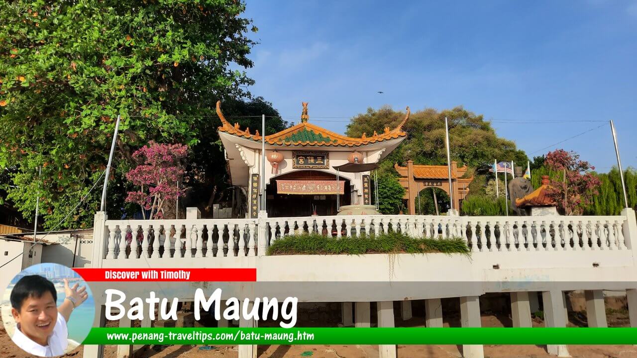 Batu Maung, Penang (10 January 2022)

Also available: Batu Maung, Pulau Pinang (Edisi Melayu) & 峇都茅(Batu Maung)
Batu Maung (Chinese: 峇都矛; Penang Hokkien: Ba3tu1 Mau2) is a coastal locality at the southeastern end of Penang Island, Malaysia. Once known primarily as a small fishing village, it has grown into an important transport and industrial area following the development of the Second Penang Bridge, nearby industrial estates and new housing projects. Batu Maung remains associated with fishing, seafood, the Sam Poh Footprint Temple and the Penang War Museum, which occupies the hills above the settlement.
Quick Facts
- Name: Batu Maung (峇都矛)
- Location: Southeastern Penang Island, Penang, Malaysia
- Coordinates: Approximately 5.28491, 100.2875
- Administrative district: Southwest Penang Island District (Daerah Barat Daya)
- Character: Coastal settlement, fishing area, industrial zone and residential locality
- Major road connections: Jalan Batu Maung, Jalan Permatang Damar Laut and the Tun Dr Lim Chong Eu Expressway
- Nearby landmark: Second Penang Bridge island approach
- Main attractions: Penang War Museum and Sam Poh Footprint Temple
- Nearby areas: Bayan Lepas, Bayan Baru, Teluk Tempoyak and Permatang Damar Laut
- Public transport: Rapid Penang bus services, including Route 302 between Weld Quay and Batu Maung; verify current routes and schedules before travelling
Geography and Location
Batu Maung lies on the southeastern coast of Penang Island, facing the waters between the island and the mainland. Its coastal position has shaped the settlement's traditional fishing activities, while the surrounding hills and headland give the locality a landscape different from the more densely built-up areas around George Town.
The locality includes the older village centre, fishing facilities, residential neighbourhoods and areas that have been developed for industrial and commercial purposes. Smaller settlements and neighbourhoods associated with the wider area include Kampung Seronok, Kampung Binjai, Permatang Damar Laut, Teluk Tempoyak and Jalan Baru. The names and boundaries used locally may differ from those applied in formal administrative maps.
Two important roads are Jalan Batu Maung and Jalan Permatang Damar Laut. Jalan Batu Maung serves the village and industrial areas, including facilities connected with fisheries and freight. Jalan Permatang Damar Laut links the coastal locality with other parts of southeastern Penang Island. The Tun Dr Lim Chong Eu Expressway provides a major road connection towards Bayan Lepas and the wider island road network.
The island approach to the Second Penang Bridge, officially known as the Sultan Abdul Halim Mu'adzam Shah Bridge, is located in the Batu Maung area. The bridge crosses the channel to Batu Kawan on the mainland and has strengthened the locality's role as a gateway between Penang Island and Seberang Perai.
History of Batu Maung
From fishing village to growing township
For much of its history, Batu Maung was a relatively small coastal settlement whose residents included fishing families. Fishing boats landed their catch along the shore, and local residents could buy fish directly from fishermen as they returned from the sea. The village's proximity to fishing grounds made seafood an important part of its economy and everyday life.
In earlier decades, the surrounding landscape was less built-up than it is today. Residential properties stood among open land, vegetation and rural roads. Parts of the coast contained mangrove habitat, while the hills above the village remained comparatively undeveloped. As development spread through southeastern Penang, this landscape gradually changed.
Industrial expansion around Bayan Lepas brought more employment and transport activity to the southern part of the island. Warehouses, freight-related businesses and other industrial facilities appeared along key roads in Batu Maung. New housing estates also replaced some areas of open land, changing the character of roads that had previously passed through a more rural setting.
The Second Penang Bridge and modern development
The opening of the Second Penang Bridge in 2014 marked an important change in Batu Maung's regional connectivity. The bridge provides a direct road connection between southeastern Penang Island and Batu Kawan on the mainland, giving motorists an alternative to the first Penang Bridge near Gelugor and Perai.
The bridge has reinforced Batu Maung's importance as a transport corridor. The area now accommodates a mixture of residential development, industrial activity, fisheries-related facilities and commercial projects. Its location near Penang International Airport and the Bayan Lepas industrial area also contributes to its appeal for businesses and residents who need access to the southern part of the island.
Development has brought new housing and economic opportunities, but it has also changed the local landscape. The loss or alteration of mangrove areas and other coastal habitats has raised environmental concerns, particularly where development affects wildlife habitat and natural coastal systems. The extent and effects of individual projects should be assessed using current environmental and planning information rather than general assumptions.
Origin of the Name Batu Maung
The name Batu Maung is written in Chinese as 峇都矛. In Malay, batu commonly means stone or rock. The origin and intended meaning of the complete place name, however, are not conclusively established by the information available for this guide.
It is therefore preferable to distinguish the literal meaning of the individual word from the historical reason the settlement acquired its name. Without reliable documentary evidence or a well-supported local account, explanations linking the name to a particular rock, person or event should be treated cautiously.
Places of Interest in Batu Maung
Penang War Museum
The Penang War Museum occupies a former British military fortification on the hills above Batu Maung. The defensive site was constructed before the Second World War as part of the British military preparations to protect Penang. Its position overlooking the coast reflects the strategic importance once assigned to a possible seaborne attack.
During the Japanese invasion of Malaya in December 1941, Japanese forces advanced down the peninsula, and the British position in Penang became untenable. The fortifications did not prevent the fall of Penang. The surviving military structures were later developed into a museum where visitors can learn about the site's wartime history and examine features associated with its former military use. 1
The museum complex includes remnants of defensive installations and military facilities. As the site occupies hilly ground, visitors should expect slopes, steps and uneven surfaces. Comfortable footwear, drinking water and suitable protection from the sun are advisable. Check current admission arrangements and opening hours before setting out.
Sam Poh Footprint Temple
The Sam Poh Footprint Temple is a Chinese temple near the shore in the old fishing-village area of Batu Maung. It is associated with a large footprint-shaped mark in the rock, which devotees traditionally attribute to Admiral Zheng He, also known as Cheng Ho or Sam Poh. The temple developed from a more modest shrine built around the rock. 2
The footprint is part of local religious tradition and folklore rather than a historically verified trace of Zheng He's visit. Different communities have their own interpretations of the mark. The temple is nevertheless an interesting place to learn about the religious beliefs and stories that have become part of Batu Maung's cultural landscape.
The temple is located close to the fishing area, where boats and working waterfront activity form part of the scenery. Visitors should be respectful of worshippers, avoid obstructing fishing operations and follow any instructions displayed at the temple. Parking space near the older coastal area may be limited at busy times.
The fishing village and waterfront
The older fishing-village area remains an important part of Batu Maung's identity. Fishing boats, landing areas and related businesses offer a glimpse of the maritime activities that preceded the locality's industrial and residential growth. The waterfront is a working environment, so visitors should take care around jetties, moorings and areas used by fishermen.
One local landmark is known as Beginning of the World, a name associated with the tip of the Batu Maung headland. The name has been explained in local accounts as referring to the area's position at the edge of the developed part of Penang Island and its relationship to the sea. An offshore seafood restaurant once operated in this vicinity, although the history and location of individual businesses have changed over time. 3
Fisheries research and WorldFish
Batu Maung is also associated with scientific and technical work connected with fisheries. The Malaysian Department of Fisheries operates the Fisheries Research Institute in Batu Maung, where research supports the management and development of fisheries and related fields. 4
The international research organisation WorldFish is also based on Jalan Batu Maung. Its work focuses on aquatic food systems, fisheries and aquaculture, including research intended to support food security, livelihoods and the sustainable use of aquatic resources. WorldFish moved its headquarters from the Philippines to Penang in 2000. 5
These institutions are primarily research and work facilities rather than conventional tourist attractions. Visitors should not assume that their premises, laboratories or exhibitions are open to the public without prior confirmation.
Seafood and Local Food
Seafood is closely associated with Batu Maung because of its fishing heritage and location on the coast. Restaurants in and around the locality have served fish, prawns, crabs, shellfish and other seafood dishes. The range available depends on the catch, season, restaurant and prevailing supply.
Older residents may remember seafood establishments that once formed part of Batu Maung's local identity. Ocean Inn, for example, was remembered for its cement figures depicting characters from Chinese mythology. Later, restaurants operating under names such as Beginning of the World became associated with the area. These businesses are part of the locality's changing social history, but their former presence should not be taken as evidence that they continue to operate at the same locations today.
Visitors looking for a meal can explore restaurants in Batu Maung village and along the main roads, as well as the wider Bayan Lepas and Bayan Baru areas. As restaurants open, relocate or close, it is sensible to check recent listings before making a special trip.
Food for Muslim travellers
Malay and Muslim travellers should confirm the halal status of a restaurant directly rather than assuming that a seafood menu means the establishment is halal. Ask about ingredients, cooking methods and the handling of food where necessary. The wider Bayan Lepas and Bayan Baru areas offer additional dining choices, including Malay-Muslim food outlets.
Where to Stay in Batu Maung
Batu Maung is not one of Penang's principal resort districts, and visitors seeking a large selection of hotels may find it more convenient to stay in the nearby Bayan Lepas or Bayan Baru areas. These locations provide access to the airport, industrial areas, shopping facilities and the road network leading to Batu Maung.
- Batu Maung: Consider accommodation here if the purpose of the visit is to work in the area, visit the war museum or explore the old fishing village and nearby coastal localities.
- Bayan Lepas and Bayan Baru: These are practical bases for travellers who need to be near Penang International Airport, the industrial zone or shopping and dining facilities.
- George Town: Visitors who want to explore Penang's historic city, heritage buildings and wider range of attractions may prefer to stay in George Town and travel south to Batu Maung for a day visit.
When choosing accommodation, check the actual distance to the intended destination, not just whether the property is advertised as being in Penang or Bayan Lepas. Traffic conditions and the location of bridge approaches can affect journey times.
How to Get to Batu Maung
By car
Driving is one of the most convenient ways to explore Batu Maung and its surrounding attractions. From George Town, motorists can travel south through the island's main road network and connect with the Tun Dr Lim Chong Eu Expressway towards Bayan Lepas and Batu Maung. Jalan Batu Maung and Jalan Permatang Damar Laut provide access to different parts of the locality.
Travellers arriving from mainland Penang via the Second Penang Bridge reach the island in the Batu Maung area. Those using the first Penang Bridge can continue through the island's road network towards Bayan Lepas and the southeastern coast.
From Penang International Airport, Batu Maung is a relatively short drive, although the exact distance and journey time depend on the destination within the locality and current traffic. Navigation applications can help identify the best route at the time of travel.
By bus
Rapid Penang bus Route 302 connects Weld Quay in George Town with Batu Maung. It has historically been a useful public-transport option for reaching the village area. However, routes, stopping points and service frequency may change. Check the current Rapid Penang journey planner or service notices before travelling. 6
Not every attraction or residential area is necessarily within easy walking distance of a bus stop. If visiting the Penang War Museum, the Sam Poh Footprint Temple and the waterfront in one trip, consider how you will travel between the stops. A taxi or e-hailing vehicle may be more practical for the final part of the journey.
By taxi or e-hailing
Taxis and e-hailing services offer a direct way to reach Batu Maung from the airport, Bayan Lepas, Bayan Baru or George Town. This option is useful for visitors carrying luggage or planning to visit several sites in the same area. At the end of a visit to a less busy part of Batu Maung, allow time to arrange a return ride.
Getting Around Batu Maung
Batu Maung is spread across a mixture of village streets, industrial roads, residential developments and coastal areas. Although some parts can be explored on foot, the distance between the fishing village, the war museum and other destinations may make walking impractical for a complete visit.
- Walking: Suitable for short explorations of the village centre and nearby waterfront, where pedestrian access is available. Watch for traffic and avoid entering working or restricted areas.
- Car or motorcycle: Useful for travelling between the village, the museum, residential neighbourhoods and the main roads.
- Bus: A budget-conscious option for reaching Batu Maung, but check the current route and plan the final leg to each attraction.
- Taxi or e-hailing: Convenient when public transport does not stop near the intended destination or when travelling in a group.
Visitors should take particular care around industrial roads, where lorries and other heavy vehicles may be common. The hills around the war museum can also involve steep or uneven paths. Avoid walking along road edges where there is no safe pedestrian space.
Suggested Visit to Batu Maung
A half-day visit can focus on the Penang War Museum and the older fishing-village area. Start at the museum to explore the military remains and learn about Penang during the Second World War. Continue to the Sam Poh Footprint Temple and, where access is available, take a respectful look at the working waterfront. Finish with a meal at a nearby restaurant.
Visitors with more time can explore other parts of southeastern Penang, including Bayan Lepas and Bayan Baru. These areas provide additional places to eat, shop and stay, while Batu Maung itself offers a view of how a traditional coastal settlement has adapted to industrial development and new transport links.
Practical Tips for Visitors
- Check the latest opening hours and admission details for the Penang War Museum before visiting.
- Wear comfortable shoes for the museum's hilly terrain and bring drinking water.
- Dress and behave respectfully at the Sam Poh Footprint Temple, particularly when worshippers are present.
- Remember that the fishing waterfront is a working area; do not obstruct fishermen, boats or loading activities.
- Confirm restaurant locations and operating status before travelling specifically to a named seafood establishment.
- Check Rapid Penang route information before relying on a bus for a time-sensitive journey.
- Allow additional time during busy periods, especially when travelling on roads serving the airport, industrial estates and Second Penang Bridge.
Conclusion
Batu Maung combines the character of an old fishing settlement with the transport and industrial functions of modern Penang. Its fishing heritage, seafood culture, Sam Poh Footprint Temple and Penang War Museum give the area historical and cultural interest, while the Second Penang Bridge and nearby industrial developments have reshaped its role within the island. For visitors interested in understanding southeastern Penang beyond its best-known tourist districts, Batu Maung offers a useful glimpse of the island's changing coastal landscape.
 Map of Batu Maung
Amenities in Batu Maung
- Batu Maung Post Office (GPS: 5.28534, 100.28624)

 Apartments and Condominiums in Batu Maung
- Desa Jelita (GPS: 5.2779, 100.27263)

- Desa Kayu Manis (GPS: 5.27722, 100.2739)

- Desa Wangsa (GPS: 5.27787, 100.27098)

- M Amaya (GPS: 5.28403, 100.29007)

- M Zenni (GPS: 5.28406, 100.28969)

- Southbay Plaza (GPS: 5.28475, 100.28888)

- The Loft (GPS: 5.28197, 100.28785)

Businesses in Batu Maung
- 7-Eleven
- BB Futsal (indoor football arena)
- Indian Barber Shop
- Kim San Mini Market
- LL Challenger Motor (motorcycle dealer)
- LSS Green Innovation Lifestyle Concept (lighting)
- Lye Biaw Motor (motorcycle repair)
- OCBC Bank
- Pheng Motors (motorcycle repair & dealer)
- Siew Eng Motor (auto service)
- Sonic Motor Enterprise (motorcycle repair & dealer)
- OCBC Bank - Batu Maung Branch
- OK Auto Mart
- Orion Car Accessories Auto Mart
- Yew Tat Hardware & Electrical Supplies
Chinese Temples in Batu Maung
- Batu Maung Bottle Temple (GPS: 5.2809, 100.28529)

- Cheng Chooi Keong Temple (formerly Chor Soo Kong Temple) (GPS: 5.28118, 100.28636)

- Sam Poh Footprint Temple (GPS: 5.28505, 100.29078)

Coffee Shops in Batu Maung
- 1178 Food Corner
- Astaka Batu Maung (GPS: 5.29554, 100.28011)

- Batu Maung Jalan Baru Food Court
- Chai Seafood
- Kedai Kopi dan Makanan Bond Bond (GPS: 5.29571, 100.28022)

- NSN Kopitiam
- Restoran Lye
- Restoran Nasi Kandar Dinas
- Restoran Pen Mutiara
- Xin Yuen Cafe
Housing Estates in Batu Maung
- Desa Batu Maung (GPS: 5.28349, 100.28614)

- Legenda @ Southbay (GPS: 5.27936, 100.28623)

- My Sakura 28 (GPS: 5.29319, 100.25668)

- Prestige V (GPS: 5.27969, 100.27725)

- Residence @ Southbay (GPS: 5.27961, 100.28651)

- Sunway Cassia (GPS: 5.27742, 100.2741)

- Sunway Mutiara (GPS: 5.28007, 100.28149)
- Sunway Tunas Jaya (GPS: 5.28001, 100.27471)

- Taman Iping (GPS: 5.28729, 100.28323)

- Taman Sri Mewah Indah (GPS: 5.28359, 100.27771)
Industrial Parks in Batu Maung
Markets in Batu Maung
- Pasar Batu Maung (GPS: 5.29546, 100.2803)
Mosques in Batu Maung
- Masjid Jamek Batu Maung (GPS: 5.28125, 100.28372)

Neighbourhoods of Batu Maung
Parks in Batu Maung
- Tanah Lapang Lorong Bidara 5 (GPS: 5.27668, 100.27793)

Petrol Stations in Batu Maung
- Caltex Kampung Binjai (GPS: 5.28294, 100.25718)
Private clinics in Batu Maung
Roads in Batu Maung
- Gerbang Batu Maung 1
- Jalan Baru Batu Maung
- Jalan Batu Maung
- Jalan Bidara
- Jalan Jeliti
- Jalan Permatang Damar Laut
- Lebuh Batu Maung 1
- Lebuh Batu Maung 1/2
- Lebuh Batu Maung 1/3
- Lebuh Batu Maung 2
- Lebuh Batu Maung 3
- Lebuh Batu Maung 4
- Lebuh Batu Maung 6
- Lebuh Batu Maung 7
- Lebuh Batu Maung 8
- Lebuh Batu Maung 9
- Lebuh Batu Maung 10
- Lebuh Batu Maung 11
- Lebuh Batu Maung 12
- Lebuh Batu Maung 12/1
- Lebuh Batu Maung 13
- Lebuh Batu Maung 17
- Lebuhraya Batu Maung
- Lengkok Batu Maung
- Lengkok Batu Maung 1
- Lilitan Batu Maung
- Lintang Batu Maung
- Lintang Batu Maung 1
- Lintang Batu Maung 2
- Lintang Batu Maung 3
- Lintang Batu Maung 4
- Lorong Batu Maung 2
- Lorong Batu Maung 3
- Lorong Batu Maung 4
- Lorong Batu Maung 6
- Lorong Bidara 1
- Lorong Bidara 2
- Lorong Bidara 3
- Lorong Bidara 4
- Lorong Bidara 5
- Lorong Batu Nilam
- Lorong Batu Nilam 1
- Lorong Batu Nilam 2
- Lorong Batu Nilam 4
- Lorong Batu Nilam 6
- Lorong Jeliti 1
- Medan batu Maung 1
- Medan batu Maung 2
- Medan batu Maung 3
- Medan batu Maung 4
- Medan batu Maung 5
- Medan batu Maung 6
- Medan batu Maung 7
- Medan batu Maung 8
- Solok Batu Maung
- Solok Beringin
- Solok Beringin 1
Schools in Batu Maung
- Sekolah Jenis Kebangsaan (Cina) Wen Khai (GPS: 5.29475, 100.28033)

- Sekolah Kebangsaan Batu Maung (GPS: 5.28202, 100.28337)

- Sekolah Menengah Kebangsaan Batu Maung (GPS: 5.28276, 100.28571)

Sights in Batu Maung
- Batu Maung 8 Batu Neighbourhood Park (GPS: 5.28567, 100.27779)

- Goalkick Futsal Arena (GPS: 5.29573, 100.28058)

- Penang Aquarium (GPS: 5.28587, 100.28626)

- Penang War Museum (GPS: 5.28142, 100.28872)
- Puspakom Batu Maung (GPS: 5.28258, 100.27058)

- Second Penang Bridge (GPS: 5.29198, 100.29356)

- Stesen Pengurusan Sisa Pepejal Batu Maung (GPS: 5.29169, 100.29283)

- Taman Iping Neighbourhood Park (GPS: 5.28572, 100.2804)

References
- Visit Penang: Penang War Museum.
- Penang Travel Tips: Sam Poh Footprint Temple, Batu Maung.
- Penang Travel Tips: Beginning of the World.
- Department of Fisheries Malaysia: Fisheries Research Institute.
- WorldFish: Contact and Headquarters Information.
- MyRapid Journey Planner.
- Penang Travel Tips: Batu Maung.
Page Details
This page was created on 15 October 2026. Hi, my name is Timothy and created it from my research, for my own entertainment, knowledge and to satisfy my curiosity. I am providing the information to you in good faith and hope it is useful. I try to get the details as accurate as possible. I also try to update the page whenever I stumble on new details. So this and all my other pages are perpetual work in progress. If you discover any error, please politely inform me, pointing out where the error lies, and I will correct it as soon as possible. Your helpfulness will keep this page accurate, relevant and helpful to those who need the information.Want to share your Penang travel experiences or get tips from fellow travellers?
Join the Penang Travel Tips Facebook GroupUseful guides for visiting Penang
My Videos of Penang
Latest Pages & Updates
Buy Me A Coffee
If you enjoy the information I provide and want to support the work I do, please buy me a coffee! I appreciate it immensely, thank you so much!
