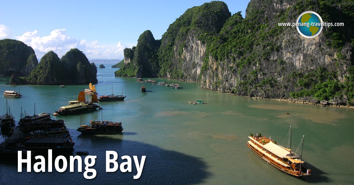
 Halong Bay, Vietnam (31 August, 2006)
Halong Bay (Vietnamese: Vịnh Hạ Long
 ) is a tourist destination in the Gulf of Tonkin in northern Vietnam. It was recognised by Unesco as a World Heritage Site since 1994. I visited it with my wife (then girlfriend) and a small group of AsiaExplorers members, on a tour arranged through our hotel. We toured the bay in a traditional junk and spent the night on board. Located 170 km east of Hanoi, Halong Bay took me over three hours to reach.
The weather in Hanoi was balmy with light rain, so we were pleasantly surprised that upon reaching Halong Bay, we were treated with glorious sunshine. It was one of the sunniest days I have had on the whole trip, and it allowed me to take many great photographs of this scenic bay.
Halong Bay was inscribed as one of Vietnam's World Heritage Sites in 1994.
Places of Interest in Halong Bay
World Heritage Site Inscription Details
Location: N20 53 60 E107 5 60Inscription Year: 1994
Type of Site: Natural
Inscription Criteria: VII, VIII
Translated into English, Vinh Ha Long means Bay of the Descending Dragon. The origin of this name is linked to one of the many skirmishes the Vietnamese had with their mighty neighbour up north, China.
According to legend, during one of the invasions mounted by the Chinese on Vietnam, the Vietnamese called upon the gods for assistance. The gods sent a troop of dragons to help defend the land. The dragons descended in Vietnam at Halong Bay. Out of their mouths came - not fire - but jewels, and these jewels transformed into the many isles and islets dotting the bay. These tiny islands became a natural shield against sea invasion, and three times in Vietnamese history, the labyrinthine passages through the islands prevented the Chinese from landing. Even the Mongols were thwarted in their 13th century attempt to conquer Vietnam - the Vietnamese led by General Tran Hung Dao planted steel-tipped wooden stakes into the sea bed. When the Mongol fleet passed through them, the stakes punctured their ships, sinking them.
Halong Bay covers an area of 1500 square kilometres. Within this area is close to two thousand limestone islands (someone counted and claimed there're 1969 islands) that jut out in spectacular fashion from the sea. The islands are similar to those at Phangnga Bay in Thailand, and come in unusual shapes.
Some of the islands in Halong Bay have rather fancy names such as Fighting Cock Island, a pair of limestone outcrops that look more like a two chicks about to, not fight, but kiss. There are so many islands, but the ones I can name include Yen Ngua Islet, Ba Trai Dao Islet, Con Coc Islet, Cong Do Island, Soi Sim Islet. We stopped over at Ti Top Island where we climbed up to the view point right up at the top.
The islands of Halong Bay are pockmarked with caves and grottoes. The largest of these is Sung Sut Cave. The scenery from the mouth of the cave is simply postcard perfect. The other significant caves in Halong Bay include Ba Ham Cave, Bo Nau Cave, Dau Go Cave, Kim Quy Cave, Luon Cave, Me Cung Cave, Tam Cung Cave, Thien Cung Cave and Trinh Nu Cave.
Going to Halong Bay
I think the simplest method is simply to book a tour package from any agencies in Hanoi. There are plenty of itineraries to choose from, and it beats the hassle of hammering something together yourself. Latest updates on Penang Travel Tips
 Map of Roads in Penang
Looking for information on Penang? Use this Map of Roads in Penang to zoom in on information about Penang, brought to you road by road.
Copyright © 2003-2025 Timothy Tye. All Rights Reserved.

 , Vietnam
 Go Back