
Pan Island Link 1
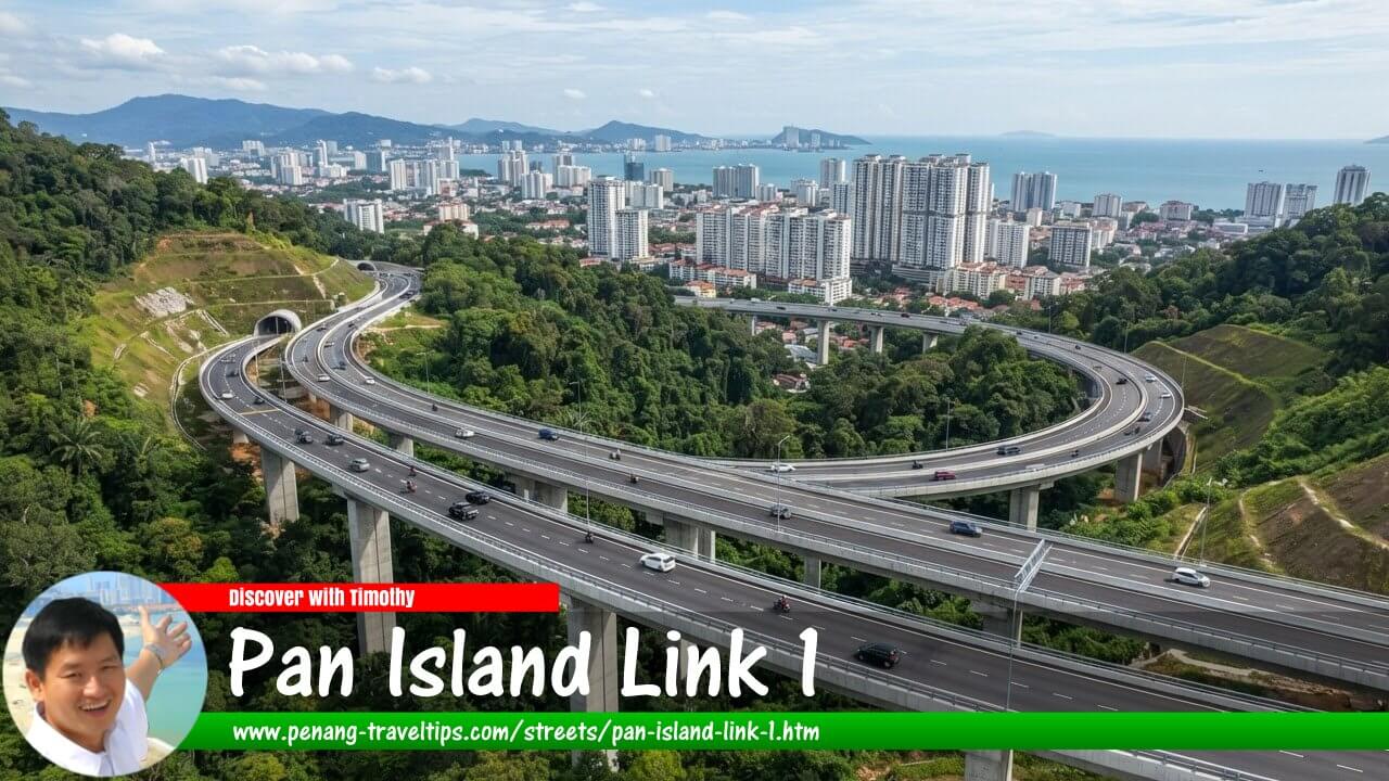 Artist impression of the Pan Island Link 1 (AI generated on 8 September 2026)
Also available: Pan Island Link 1 (Malay Edition)
Pan Island Link 1 (PIL 1) is a proposed 20-kilometre highway on Penang Island, conceived as a second north-south spine road to supplement the existing Tun Dr Lim Chong Eu Expressway. The project is intended to provide an alternative route between the densely developed northern part of the island and the Bayan Lepas area in the south, while dispersing traffic from existing roads. Although commonly described as a 20-kilometre highway, more detailed project descriptions put the proposed alignment at approximately 19.5 kilometres. 1
PIL 1 forms part of the wider Penang Transport Master Plan (PTMP), which proposes a combination of new highways, bypasses and public transport infrastructure to improve connectivity across Penang. The highway is particularly significant because the existing Lebuhraya Tun Dr Lim Chong Eu is the island's principal north-south road, carrying traffic between George Town, the Penang Bridge, Bayan Lepas, the airport and the industrial areas along the eastern and southern coast. Penang Infrastructure Corporation describes PIL 1 as the island's proposed second north-south spine road. 1
Quick Facts
- Name: Pan Island Link 1 (PIL 1)
- Location: Penang Island, Penang, Malaysia
- Type: Proposed limited-access highway
- Approximate length: 20 km; detailed alignment approximately 19.5 km
- Road configuration: Dual three-lane highway
- Toll status: Planned as toll-free
- Function: Second north-south spine road and traffic dispersal route
- Northern connection: Gurney area / Persiaran Gurney
- Southern connection: Lebuhraya Tun Dr Lim Chong Eu near Bayan Lepas
- Interchanges: Six planned strategic interchanges
- Major structures: Elevated sections, tunnels and a cable-stayed bridge
- Current status: Proposed project undergoing further study and review
Purpose of PIL 1
The principal purpose of PIL 1 is to provide an alternative to the existing north-south road system. Penang Infrastructure Corporation identifies Lebuhraya Tun Dr Lim Chong Eu as the island's existing north-south spine and says that increasing traffic has placed the route and adjoining arterial roads under pressure. PIL 1 is therefore intended to operate as a traffic-distribution route rather than simply as another local road. 1
The proposed highway would allow longer-distance traffic to bypass some of the more heavily developed parts of the island. In particular, the proposed route is intended to provide an alternative to congested corridors around Jalan Scotland, Jalan Masjid Negeri, Jalan Ayer Itam, Jalan Paya Terubong and Jalan Bukit Gambir. The objective is to separate through traffic from local traffic and reduce pressure on roads that now perform several functions simultaneously. 1
The project is therefore better understood as a traffic dispersal system than simply a fast road between two points. By providing limited points of access, PIL 1 is intended to offer more predictable journey times for motorists travelling between the north and south of the island. The official project description gives an indicative journey time of about 15 minutes between the northern and southern ends, compared with about 45 minutes under congested conditions on the existing network. 1
Route and Strategic Connections
The proposed PIL 1 would extend from the Gurney area in the northeast towards the Bayan Lepas area in the southwest. Earlier descriptions of the project identify Gurney Drive as the northern end and the Lebuhraya Tun Dr Lim Chong Eu as the southern end. The route would pass inland of much of the densely developed urban area, allowing it to function as an outer bypass for north-south traffic. 2
The highway is planned with six strategic interchanges. Penang Infrastructure Corporation identifies connections involving the Gurney Expressway, Persiaran Kuari, the existing LCE corridor, Tun Dr Awang and Paya Terubong, together with links to major transport infrastructure including the Penang Bridge, the Sultan Abdul Halim Muadzam Shah Bridge and Penang International Airport. The exact arrangement and alignment remain subject to review before implementation. 1
These connections are important because the proposed highway is not intended to serve only traffic travelling from Gurney to Bayan Lepas. Its interchanges would allow motorists to enter and leave the route at selected locations, distributing traffic towards different parts of the island and connecting major transport gateways.
A Six-Lane Highway
PIL 1 is planned as a dual three-lane highway, giving it six traffic lanes in total. Unlike an ordinary urban arterial road, it would have limited access points. This configuration is intended to maintain relatively consistent traffic flow and reduce the interruptions caused by frequent junctions and roadside access.
The highway would consequently have a different character from existing roads such as Jalan Masjid Negeri or Jalan Paya Terubong. Those roads have developed within established urban neighbourhoods and serve local properties, businesses, schools and other destinations. PIL 1 is instead conceived as a higher-capacity strategic route whose principal function is to move traffic across the island.
Tunnels and Elevated Sections
One of the most distinctive characteristics of PIL 1 is the amount of complex engineering required to cross Penang's central hills. The proposed highway would not simply be constructed as a conventional surface road. Project descriptions envisage a combination of elevated viaducts, tunnels and at-grade or embankment sections.
More detailed descriptions of the proposed 19.5-kilometre alignment identify approximately 7.6 kilometres of elevated road and about 10.1 kilometres of tunnel sections, with the remainder consisting of other road sections. 3 The tunnels are intended to allow the highway to cross the mountainous centre of the island without requiring a continuous surface road through steep terrain.
The use of tunnels is also presented by the Penang state government as a means of reducing the physical footprint of the project in sensitive hill environments. The state has highlighted tunnelling and cable-stayed bridge technology as engineering measures intended to reduce social and environmental impacts compared with extensive surface construction. 4
Environmental Considerations
The route through Penang's central hills has made environmental considerations an important part of the discussion surrounding PIL 1. The project requires substantial tunnelling and elevated structures because the central spine of Penang Island contains steep hills, forested areas and important water catchments.
An Environmental Impact Assessment for PIL 1 was previously approved. However, the Penang state government acknowledged in January 2025 that the earlier EIA had expired and that updated information would have to be incorporated before the project could proceed. The state said it intended to update the assessment and resubmit it for review and approval before construction. 4
This distinction is important when describing the project. PIL 1 should therefore be regarded as a planned and proposed highway rather than an under-construction road. Its alignment, engineering details and implementation arrangements may still be revised as further studies and approvals are undertaken.
Project Cost and Funding
The projected cost of PIL 1 has changed over the course of the proposal. By 2025, the estimated total cost was reported at approximately RM8.88 billion. The Penang state government sought federal funding to enable the project to move forward, including a proposed allocation for the first year of the 13th Malaysia Plan. 5
The financing question is significant because PIL 1 was originally presented as a toll-free highway. The Penang government's current project information continues to describe PIL 1 as toll-free. At the same time, discussions have taken place over the project's funding and possible financing arrangements. In 2024, the state administration submitted a proposal seeking approval for PIL 1 to be implemented as a tolled highway, illustrating that the project's financial structure has been subject to consideration and change. 6
For this reason, the highway's planned toll-free status should be understood as the current stated project objective, rather than evidence that a final operating and financing arrangement has already been established.
Role in Penang's Transport Network
PIL 1 is one component of a much larger restructuring of Penang's transport network. The broader plan includes other proposed bypasses and highway links, as well as major public transport projects. The intention is to create a more interconnected network in which strategic traffic can move around congested urban areas instead of being forced onto a small number of existing corridors.
For Penang Island, the strategic importance of PIL 1 lies in its position between the northern urban area and the southern economic zone. Bayan Lepas contains the international airport and major industrial areas, while the northern part of the island contains George Town and its surrounding urban districts. A second north-south route would therefore provide an alternative connection between two major concentrations of population, employment and transport activity.
Current Status
As of 2026, PIL 1 remains a proposed project rather than a completed or operational highway. The latest federal procurement information shows that the Ministry of Works has advertised consultancy services for a traffic and land-use study relating to the proposed Pan Island Link in Penang. The tender was advertised in March 2026, with the sale of tender documents taking place in August 2026. 7
The new study indicates that the project is still undergoing assessment before implementation. This is consistent with the Penang Infrastructure Corporation's statement that the alignment is subject to review prior to implementation. Consequently, the 20-kilometre description, six-interchange arrangement, engineering design and other characteristics should be treated as the current proposal rather than as fixed details of a highway already under construction. 1
Significance of PIL 1
If implemented substantially as proposed, PIL 1 would become one of the most important road projects in Penang's modern transport history. Its significance would extend beyond the construction of another highway because it would introduce a second strategic north-south corridor across Penang Island.
The project is intended to relieve pressure on the Lebuhraya Tun Dr Lim Chong Eu and other major arterial roads, improve connections between northern and southern Penang Island, and provide more direct access to important transport facilities. At the same time, its construction through the island's central hills means that engineering, environmental protection, funding and land-use considerations will remain central to its future.
For of time of writing (8 Sept 2026), Pan Island Link 1 remains a proposed highway whose final form depends on further traffic, land-use, environmental, financial and engineering studies. Its continuing inclusion in state and federal transport planning demonstrates its strategic importance, but the latest studies also show that the project has not yet reached the point where its final alignment and construction timetable can be regarded as settled.
Map of the Pan Island Link 1 Highway (PIL1)
Further Reading
- The Edge Markets (17 April 2019): Penang's Pan Island Link 1 project is not a waste of funds
- The Star (17 April 2019): PIL 1 highway is not a waste of money
- DAP Malaysia (17 April 2019): Answering concern about Pan Island Link 1
- EdgeProp (16 April 2019): DOE approves Pan Island Link 1 EIA report
- Malay Mail (15 April 2019): Penang gets EIA nod for Pan Island Link 1 project
- Malaysiakini (15 April 2019): EIA for Penang's Pan Island Link 1 approved
- New Straits Times (13 September 2018): Penang govt to hold townhall on controversial Pan Island Link 1 project
- Penang Property Talk (27 August 2018): 85% Say "Yes" to Pan Island Link
- Malay Mail (9 August 2018): Don't compare Pan Island Link 1 Highway with East Coast Rail Link, says Penang CM
References
- Penang Infrastructure Corporation — Highways and Roads: Pan Island Link 1. 1
- Penang Travel Tips — Pan Island Link 1 Highway. 2
- The Edge / EdgeProp — Penang infrastructure report, including Pan Island Link 1. 3
- Penang State Executive Council — Media Statement on PIL 1, 13 January 2025. 4
- New Straits Times — Penang submits RM17 billion worth of projects under 13th Malaysia Plan. 5
- Penang State Government transport portfolio response — PIL 1 financing and toll proposal. 6
- Ministry of Works Malaysia — Consultancy services for traffic and land-use study for the proposed Pan Island Link, Penang. 7
Pan Island Link 1 on the Map of Roads in Penang
Page Details
This page was created on 8 September 2026. Hi, my name is Timothy and created it from my research, for my own entertainment, knowledge and to satisfy my curiosity. I am providing the information to you in good faith and hope it is useful. I try to get the details as accurate as possible. I also try to update the page whenever I stumble on new details. So this and all my other pages are perpetual work in progress. If you discover any error, please politely inform me, pointing out where the error lies, and I will correct it as soon as possible. Your helpfulness will keep this page accurate, relevant and helpful to those who need the information.Want to share your Penang travel experiences or get tips from fellow travellers?
Join the Penang Travel Tips Facebook GroupUseful guides for visiting Penang
My Videos of Penang
 Latest Pages & Updates
Buy Me A Coffee
If you enjoy the information I provide and want to support the work I do, please buy me a coffee! I appreciate it immensely, thank you so much!
