Docklands, London
 London Docklands at night
Source: https://commons.wikimedia.org/wiki/File:08-14-05_Royal_Victoria_Dock.jpg
Author: Michael Pead

Docklands is the semi-official name given to the area east of London, England. The docks were once part of the Port of London, which was once the world's largest port. Today they have been redeveloped for commercial and residential use. The name London Docklands first appeared in a government report of 1971. Today it is almost universally recognised. The Docklands comprise the boroughs of Southwark, Tower Hamlets, Newham and Greenwich, all within Greater London.
The history of Docklands goes back to Roman and medieval times, when ships dock at small quays along present-day City of London and Southwark. As these offered no protection against the elements, the Howland Great Dock in Rotherhithe was built to address these problems. It proved to be a big successful, and provided the template for later docks built during the Georgian and Victorian eras. The first of the Geogian docks was the West India Dock opened in 1802. This was followed by the London Dock (1805), the East India Dock (also in 1805), the Surrey Dock (1807), St Katharine Dock (1828) and the West India South Dock (1829). During the Victorian era, the docks were built further east. They included the Royal Victoria Dock (1855), Millwall Dock (1868), and the Royal Albert Dock (1880). In 1921, the King George V Dock was added, and was only in use till the 1950s.
The dockland areas were mostly low-lying marshland that were not suitable for agriculture. The establishment of the docks created its own tight-knit local communities. These communities tend to be inward looking and develop in some isolation. The Isle of Dogs had only two roads going in and out. In 1920, the residents even blocked the roads and declared independence. Such as the local sentiment at the Docklands.
The docklands suffered massive damage from German bombing during the Second World War. Post-war rebuilding saw a resurgence of prosperity in the 1950. However, the introduction of container system of cargo spelled the end for the docklands which were not able to accommodate the larger vessels for containerization, and the shipping industry moved to deep-water ports such as Tilbury and Felixstowe. The closure of the docks between 1960 and 1980 created vast tracts of derelic wasteland in East London, giving rise to high unemployment, poverty and other social problems.
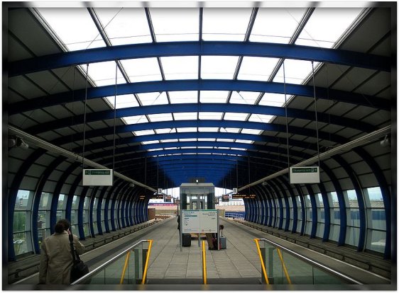
 London City Airport DLR Station
Source: https://commons.wikimedia.org/wiki/File:London_City_Airport_DLR_Station_%281%29.jpg
Author: uggboy

Although efforts to redevelop the Docklands began almost as soon as the docks were closed, nothing left the drawing board for a decade, and even then, another decade would pass before redevelopment take full effect. In 1991, the London Docklands Development Corporation, or LDDC, was formed to redevelop the area. In 1982, to expedite the redevelopment, the government created an enterprise zone where businesses are exempt from property taxes, making investing in the Docklands particularly attractive.
The LDDC attracted controversy. One of the criticisms was that it favored elitist luxury developement over affordable housing, and hence, did not receive the support of the local community there, which felt it did not address their needs. Nevertheless, the 1980s and 1990s saw massive development programmes taking place in the Docklands. The most iconic was the Canary Wharf project, which included Britain's tallest building, and the establishment of a second financial centre for London, after the City of London. But even the Canary Wharf project got into trouble. The property slump of the 1990's halted all development in the Docklands for years.
To improve the transport connection between the Docklands and London, the Docklands Light Railway (DLR) was constructed. By making use of disused railway infrastructure, the DLR was incredibly inexpensive to construct - the first phase only cost £77 million. The LDDC had wanted a Tube line but the governement refused to fund it. Another infrastructure improvement by the LDDC was the Limehouse Link tunnel, built to connect the Isle of Dogs to the A13 road. It cost £150 million per kilometer, making it one of the most expensive stretches of road ever built. The London City Airport was also developed, and opened for flights in October, 1987.
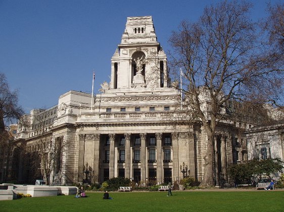
 Port of London Building, Trinity Square, Docklands
Source: https://commons.wikimedia.org/wiki/File:PLA_Building_facing_Trinity_Square_-_geograph.org.uk_-_74940.jpg
Author: David Williams

Today, with twice the population than before redevelopment started, the Docklands has become both a major business centre for London and an increasingly acceptable area to live. The Isle of Dogs finally got its Tube connection via the Jubilee Line Extension that opened in 1999. The DLR was also extended to Beckton, Lewisham, London City Airport, North Woolwich and Stratford. Canary Wharf has the biggest concentration of skyscrapers in Europe and rivals the City of London as London's financial centre.
While most of the wharves and warehouses have been demolished, some were converted into flats. The docks themselves now find new life as marinas and watersports centres. As a result of the redevelopment happening in the Docklands, neighboring areas such as Greenwich and Deptford also undergo large-scale redevelopment, mainly because the improvement in transport links has made them more attractive to commuters.
One drawback of the Dockland redevelopment, which saw a soaring in property prices, was the friction it created between the old Docklands inhabitants and the new arrivals. The sight of luxurious executive condominiums set against dilapidated public housing make for some of the most striking disparities in Britain.