Proposed Prangin Canal Park
 Go Back - HOME | Latest PENANG | Travel Tips | Penang Hokkien : Dictionary | YouTube | Facebook | Contact Me
Prangin Canal Park is a major urban park proposed by the George Town Special Area Plan. Covering 3.2 acres, it will be the biggest proposed park in the Inner City of George Town, apart from the existing Esplanade Park. The proposed park is in line with the gentrification of the Prangin Canal area for public recreation.
The Prangin Canal Park will follow the course of the Prangin Canal along Jalan Dr Lim Chwee Leong and Prangin Road Ghaut. It starts at Carnarvon Street and ends at the Tun Dr Lim Chong Eu Expressway.
For much of the 19th century, it forms the boundary demarcating the town from the hinterland. Pitt Street, which itself marked the western boundary of Francis Light's George Town, continues as Lower Pitt Street, to end at the Prangin Canal. Lower Pitt Street was eventually renamed after the Earl of Carnarvon.
Towards the 20th century, the Prangin Canal area was a hive of activities as the main market of George Town has been relocated there. The Chinese population gave it the name Sia Boey , meaning "town's edge". For much of the 20th century, the Sia Boey Market served as the main wholesale market for the city of George Town, while the Prangin Canal was reduced to a ditch, obscured by market stalls and in placed covered over.
After the Sia Boey Market was relocated at the start of the 21st century, several proposals were tossed around over the fate of the site. The proposal to turn it into the Prangin Canal Park provides a much-needed green island in a sea of concrete and asphalt.

The Prangin Canal Park will follow the course of the Prangin Canal along Jalan Dr Lim Chwee Leong and Prangin Road Ghaut. It starts at Carnarvon Street and ends at the Tun Dr Lim Chong Eu Expressway.
Appreciating the Historic Significance of this Site
The Prangin Canal Park rehabilitates for public use one of the most important waterways in George Town. The Prangin Canal was originally a river flowing through the swampy marshland to empty into the Channel. Over time it was canalised, with embarkment built on both sides.For much of the 19th century, it forms the boundary demarcating the town from the hinterland. Pitt Street, which itself marked the western boundary of Francis Light's George Town, continues as Lower Pitt Street, to end at the Prangin Canal. Lower Pitt Street was eventually renamed after the Earl of Carnarvon.
Towards the 20th century, the Prangin Canal area was a hive of activities as the main market of George Town has been relocated there. The Chinese population gave it the name Sia Boey
, meaning "town's edge". For much of the 20th century, the Sia Boey Market served as the main wholesale market for the city of George Town, while the Prangin Canal was reduced to a ditch, obscured by market stalls and in placed covered over.After the Sia Boey Market was relocated at the start of the 21st century, several proposals were tossed around over the fate of the site. The proposal to turn it into the Prangin Canal Park provides a much-needed green island in a sea of concrete and asphalt.
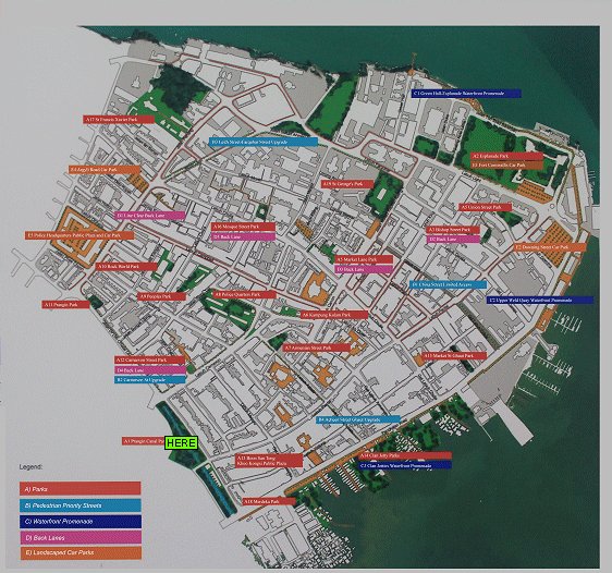
Location Map of Prangin Canal Park
Location of the public realm is marked with "HERE".
Buy Me A Coffee
If you enjoy the information I provide and want to support the work I do, please buy me a coffee! I appreciate it immensely, thank you so much!
 Backtrack | HOME | Latest Updates |
Copyright © 2003-2026 Timothy Tye. All Rights Reserved.