
Bukit Tok Alang (Frog Hill)
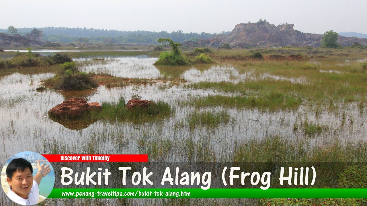 Bukit Tok Alang (Frog Hill) (1 August 2015)

Also available: Bukit Tok Alang (Frog Hill) (Edisi BM)
Bukit Tok Alang (GPS: 5.44309, 100.47733), better known as Frog Hill or Bukit Katak, is a former excavation site in Tasek Gelugor, Seberang Perai Utara, Penang. It became known for its unusual landscape of reddish earth, steep hillocks and water-filled excavation pits, whose contrasting colours created a scene reminiscent of the famous Jiuzhaigou landscape in China. However, the site is on private property, and access has been restricted because of safety concerns. Visitors should not assume that it is open to the public.
Quick Facts
- Name: Bukit Tok Alang
- Common names: Frog Hill and Bukit Katak
- Location: Jarak Atas, near Kampung Guar Petai, Tasek Gelugor, Seberang Perai Utara, Penang
- GPS coordinates: 5.44309, 100.47733
- Geographical setting: Former excavation land surrounded by agricultural areas
- Historical land use: Excavation for raw materials used in brickmaking
- Landscape: Reddish earth mounds, exposed slopes and water-filled excavation pits
- Known for: Its unusual scenery and photography appeal
- Ownership: Private estate
- Access: Restrictions have been reported; obtain permission before considering a visit
Geography and Location
Bukit Tok Alang is situated in the rural interior of northern Seberang Perai, within the wider Tasek Gelugor area. It lies near Jarak Atas and Kampung Guar Petai, among agricultural land that includes paddy fields and oil palm plantations. The location is approximately 15 kilometres northeast of Butterworth, although the actual journey depends on the route taken. 1
The surrounding countryside is characteristic of the agricultural landscape of northern Seberang Perai. Paddy cultivation occupies relatively flat land in the wider Padang Menora area, while oil palm estates cover other parts of the rural landscape. Against this setting, the excavated terrain of Bukit Tok Alang stands out because of its exposed earth, irregular hills and pools.
Although the name suggests a natural hill, the unusual terrain seen in photographs is largely the result of human excavation. The removal of earth and other raw materials created depressions, embankments and steep slopes. Following the cessation of excavation, rainwater accumulated in some of the pits, while vegetation gradually grew across parts of the disturbed land.
History of Bukit Tok Alang
From Agricultural Estate to Excavation Site
The wider estate was formerly associated with rubber cultivation, which was subsequently replaced in part by oil palm. According to published accounts of the site, excavation began in the early 1970s to obtain raw materials for a nearby clay brick factory. The excavation transformed part of the estate from agricultural land into a landscape of exposed earth and irregular pits. 1
When the extraction activities ceased, the excavated land was left with little of the appearance of an ordinary plantation. Pits filled with water, slopes became exposed to weathering, and vegetation began to reclaim portions of the site. The resulting scenery was not originally designed as a tourist attraction; it developed as a consequence of the former industrial use of the land.
Emergence as a Tourist Attraction
Bukit Tok Alang attracted wider public attention when photographs of its unusual landscape began circulating online. By 2015, the abandoned excavation site had received media coverage and was being described as a scenic destination in Penang. Its reddish slopes and blue-green pools made it particularly appealing to photographers and visitors looking for unusual landscapes. 2
Visitors came to admire the scenery, take photographs and explore the uneven terrain. Some also used the location for wedding photography. The combination of exposed earth, water and vegetation gave the former excavation site an appearance unlike the more familiar attractions of Penang, which include beaches, heritage streets and forested hills.
However, increasing public interest also raised concerns about safety and the responsibilities associated with allowing visitors onto private land. The steep slopes, deep pools and lack of purpose-built visitor facilities made unrestricted access potentially hazardous.
Private Property and Access Restrictions
Bukit Tok Alang Estate is private property. During a visit documented on this website, a guard at the entrance explained that visitors were being prevented from entering because of concerns about accidents. The hazards identified included falls from steep slopes, drowning in the water-filled pits and encounters with potentially dangerous wildlife, including snakes and scorpions.
The restriction was intended to reduce the risk of accidents on land that had not been developed or maintained as a public recreation area. Unlike a managed nature park, the site did not have the infrastructure normally expected of a formal tourist attraction, such as secured viewing platforms, marked trails, protective barriers or lifeguards.
The landowner's future plans for the site were not established in the account recorded during that visit. The possibility of residential development was mentioned as speculation by the guard, rather than as a confirmed development proposal. No conclusion about the current or future use of the land should be drawn from that historical observation alone.
As access conditions can change, the safest approach is to treat Bukit Tok Alang as a restricted private site unless the landowner or an authorised party confirms otherwise. Its former popularity as a photography destination does not in itself constitute permission to enter.
How Bukit Tok Alang Got Its Name
The name Bukit Tok Alang is the Malay name associated with the hill and estate. In Malay, bukit means hill, while Tok Alang appears to be a personal or honorific name associated with the place. However, a reliable historical account establishing who Tok Alang was, or how the name originated, has not been identified. It is therefore preferable not to assign a specific origin to the name without further evidence.
The location is also widely known as Frog Hill, or Bukit Katak in Malay. The English name is a popular informal name for the landscape rather than a description of a formally developed attraction. The name has helped distinguish the site in travel articles and online photographs.
The approach is commonly associated with Kampung Guar Petai, but the village name and the name of the excavated site do not necessarily refer to exactly the same geographical area. Guar Petai is also used to identify the approach or turning point leading towards the former excavation land.
The Landscape of Frog Hill
Reddish Earth and Irregular Hillocks
One of the most striking features of Bukit Tok Alang is its uneven terrain. Excavation left behind earth mounds, exposed slopes and irregular hillocks, producing a landscape that contrasts sharply with the relatively flat agricultural land surrounding it.
The exposed ground can appear reddish, brown or orange, depending on the soil, lighting and weather conditions. In photographs, these colours contrast with the green vegetation and the blue-green water in the excavation pits. The resulting scenery has sometimes been compared with landscapes in Jiuzhaigou, China, although the resemblance is mainly visual and does not imply that the two places share the same geological origin.
Water-Filled Excavation Pits
Some of the excavated depressions accumulated water after extraction activities stopped. These pools became a defining feature of the landscape, especially when their surfaces appeared turquoise, greenish blue or deep blue under particular lighting conditions.
The colour of the water can vary with weather, illumination, suspended material and the physical characteristics of each pool. The appearance of clear blue water in photographs should not be interpreted as evidence that the water is clean or safe for swimming. The depth and stability of abandoned excavation pits may also be difficult to assess from the surrounding ground.
Photography and Scenic Views
Before access restrictions became an issue, Bukit Tok Alang attracted photographers seeking distinctive outdoor scenery. The contrasting colours and unusual shapes provided opportunities for landscape photography, while elevated points offered views across the pools and surrounding agricultural land.
Early morning and late afternoon light can bring out the colours and contours of landscapes of this kind. Nevertheless, photography should only take place from land where access is authorised. Visitors should not cross barriers, enter private property without permission or approach the edges of abandoned excavation pits for a better view.
How to Get to Bukit Tok Alang
Bukit Tok Alang is located inland from the main urban areas of Seberang Perai. Its general location can be identified using the GPS coordinates 5.44309, 100.47733. Kampung Guar Petai is a useful geographical reference for understanding the approach to the site.
By Car
Travellers coming from Butterworth can head towards Tasek Gelugor and the rural roads serving Kampung Guar Petai. The final approach has historically involved a laterite country track near a brick factory. Such tracks may be uneven, muddy or unsuitable for some vehicles, particularly after rain.
Navigation applications may identify the general location, but a mapped route does not confirm that the entrance is open or that visitors are permitted to proceed. Drivers should obey signs and instructions at the entrance and should not continue along private access roads without authorisation.
By Motorcycle
A motorcycle can be convenient for travelling through rural roads, but the final approach may present difficulties if the track is muddy, loose or uneven. Riders should not assume that a motorcycle can be taken all the way to the former excavation site. Access restrictions apply regardless of the vehicle used.
By Public Transport
Public transport is not a practical way to reach the excavation site itself. Travellers may be able to reach a nearby town or village by public transport, but the last part of the journey would require separate arrangements. Ride-hailing availability in the rural area should be checked in advance, particularly for the return journey.
Important Access Advice
Because Bukit Tok Alang is private land and entry restrictions have been reported, do not plan an excursion on the assumption that the site is open to visitors. Obtain explicit permission from the landowner or an authorised representative before travelling there for sightseeing or photography. If permission is unavailable, choose an established public attraction instead.
Where to Stay
Bukit Tok Alang is in a rural part of Seberang Perai rather than a developed tourist district. There is no reason to assume that accommodation is available at the site itself, and visitors should not expect facilities such as a visitor centre, public toilets, food stalls or a managed car park.
For travellers exploring the wider mainland, Butterworth is a practical base because it has a broader range of accommodation, transport connections and commercial facilities. Visitors who prefer to stay closer to the rural interior can investigate accommodation in and around Tasek Gelugor, subject to availability.
Those planning to visit several destinations on the mainland may also consider accommodation in other parts of Seberang Perai, depending on their itinerary. Hotel availability, prices and travel times should be checked before making a booking. Staying nearby does not confer permission to enter Bukit Tok Alang.
What to Eat
Bukit Tok Alang is not a food destination in its own right. As the former excavation site lies in a rural area, visitors should not expect a concentration of restaurants or permanent food stalls at the entrance or within the estate.
For meals, travellers can look for restaurants, coffee shops and local eateries in Tasek Gelugor and nearby villages. These settlements serve the surrounding residential and agricultural communities, making them more suitable places to look for everyday Malaysian food than the excavation site itself.
Depending on the establishments available, visitors may find common Malaysian dishes such as nasi lemak, roti canai, mee goreng, rice-based meals and local drinks. These are general examples of food commonly found in Malaysian towns, not a verified list of vendors operating beside Bukit Tok Alang. Check current business listings and opening hours before setting out.
It is sensible to eat before travelling into the rural area and to bring drinking water for the journey. Do not enter private land in search of a picnic spot, and take all rubbish away from any public area used during the trip.
Getting Around the Area
A car or motorcycle is generally the most practical means of exploring the rural surroundings of Tasek Gelugor and Kampung Guar Petai. The road network connects villages, agricultural areas and the larger settlements of northern Seberang Perai.
Walking may be suitable along ordinary public roads where there is adequate space and visibility, but the rural environment can have limited pedestrian facilities. Visitors should watch for passing vehicles, agricultural traffic, uneven shoulders and changing weather conditions.
The former excavation site itself should not be treated as a hiking destination open to the public. Steep and unstable slopes, water-filled pits, potentially hazardous wildlife and the absence of maintained trails can create significant risks. Do not climb the hillocks, descend into the pits or attempt to enter through another route to avoid a restricted entrance.
Visitor Safety and Responsible Travel
The unusual landscape of Bukit Tok Alang was created through excavation rather than through the development of a managed recreational site. Its appearance may be attractive in photographs, but the terrain can be hazardous.
- Respect private property: Obtain permission before entering the estate and comply with access restrictions.
- Keep away from excavation pits: Water-filled depressions may be deep, and their edges may be unstable.
- Do not swim: The water's appearance does not establish its quality or suitability for swimming.
- Avoid steep slopes: Loose earth and exposed surfaces can cause falls, especially after rain.
- Do not rely on facilities: The former excavation area should not be assumed to have toilets, drinking water, emergency assistance or maintained paths.
- Check conditions in advance: Confirm access arrangements with an authorised party before making the journey.
Conclusion
Bukit Tok Alang, popularly known as Frog Hill, is an example of how industrial activity can leave behind an unexpected landscape. The reddish earth mounds and water-filled excavation pits transformed a former source of raw materials for brickmaking into a place of photographic interest in Tasek Gelugor.
Its history also illustrates the difference between a scenic location and a public tourist attraction. Although the site became well known through photographs and media coverage, it is private property and has been subject to access restrictions because of safety concerns. Anyone interested in its history should distinguish between its former popularity and its current permission status, and should not enter without authorisation.
References
- Adrian Cheah, “The Surreal Vistas of Bukit Katak (Frog Hill)”. Background on the estate, the former excavation activities and the development of the landscape.
- The Star, “Paradise Born of a Quarry Closure”, 28 September 2015. Report on the former quarry and its emergence as a scenic destination.
- Travel 2 Penang, “Penang Mainland: Frog Hill at Tasek Gelugor”. Additional descriptions of the location and its landscape.
- Penang Travel Tips, “Bukit Tok Alang (Kampung Guar Petai), Seberang Perai, Penang”. Original location information, GPS coordinates and observations about access restrictions.
Page Details
This page was created on 22 October 2026. Hi, my name is Timothy and created it from my research, for my own entertainment, knowledge and to satisfy my curiosity. I am providing the information to you in good faith and hope it is useful. I try to get the details as accurate as possible. I also try to update the page whenever I stumble on new details. So this and all my other pages are perpetual work in progress. If you discover any error, please politely inform me, pointing out where the error lies, and I will correct it as soon as possible. Your helpfulness will keep this page accurate, relevant and helpful to those who need the information.Want to share your Penang travel experiences or get tips from fellow travellers?
Join the Penang Travel Tips Facebook GroupUseful guides for visiting Penang
My Videos of Penang
 Latest Pages & Updates
Buy Me A Coffee
If you enjoy the information I provide and want to support the work I do, please buy me a coffee! I appreciate it immensely, thank you so much!
