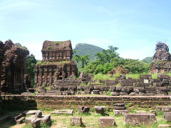
 The ruins of My Son
Source: https://commons.wikimedia.org/wiki/File:My_Son_tower2.JPG
Author: Khuong Viet Ha

Author: Khuong Viet Ha

My Son (Vietnamese: Mỹ Sơn
 ) is a site of ancient ruins in central Vietnam. It is located some 40 km (25 miles) to the southwest of Hoi An, and 69 km to the southwest of Da Nang. My Son is near the village of Duy Phu, about 10 km from the historic town of Tra Kieu.
The ruins of My Son are of Hindu temples built by the kings of the Kingdom of Champa, between the 4th and 14th centuries. The Cham people were from two different groups. The Dua people lived in the Amarvati and Vijaya provinces, while the Cau people lived in Kauthara and Pandaranga provinces. These two groups follow different customs, so over time, they eventually clashed. To avoid such clashes, the Cham people intermarry betwen the groups, as is revealede in the sculptures and carvings found.
My Son was first known to the Western world when French archaeologists discovered it in the 1890's. There are a total of 70 temple ruins in My Son, although only 20 are in good condition. The temple of My Son were built for the worship of the Hindu deity Shiva, also known locally as Bradresvara. The Cham temples were ingeniously built using dried bricks held together by resin from the cau day tree. Then a Cham tower is completed, it is encircled with fire for a few days so that the intense heat seal the bricks to the tree resin. It allowed the structures to withstand the elements and the onslaught of time - but was no match to 20th century bombs. As there may be unexploded ordnance in the area, tourists are advised not to explore off the marked paths.
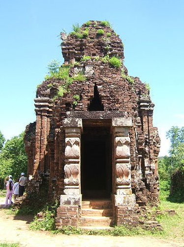
 Cham tower at My Son
Source: https://commons.wikimedia.org/wiki/File:My_Son_tower3.jpg
Author: Khuong Viet Ha

Author: Khuong Viet Ha

My Son was recognised as a World Heritage Site since 1999, during the 23rd session of the World Heritage Committee under criterion (ii), as an example of evolution and change in culture, and (iii), as evidence of an Asian civilisation that is now extinct.
The ruins of My Son are named by letters. Groups A and A1 are said to be the most impressive ruins. Unfortunately they were almost completely destroyed by USAF bombing in 1969. Groups B, C and D are situated at the center of the archaeological site. Group B is particularly interesting for exhibiting elements of Indian and Javanese art.
Group C is contiguous to Group B, with just a brick wall separating them. To the east of Groups B and C is Group D, where you can see statues of Shiva and the sacred bull, Nandi. There is also a stone Garuda, a Dancing Shiva and apsaras in Group D.
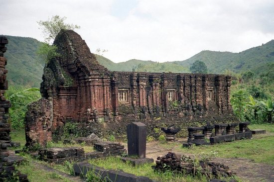
 Ruins of My Son
Source: https://commons.wikimedia.org/wiki/File:My_Son,_Vietnam.jpg
Author: Bernard Gagnon

Author: Bernard Gagnon

The ruins of Groups E, F, G and H are on the northernmost part of the archaeological site. Group E ruins are different from those of the other groups, as they do not have a vestibule, and only one of the temples here face east. The ruins of Group F and G are in a very advanced state of deterioration, though you can still see a carved lingam at Group F. There is a bas-relief of Kala, the god of time, in Group G. Group H ruins are also badly damaged. There is a stone tympanum with a dancing Shiva image. The Shiva is now on display at the Museum of Cham Sculpture.
You should also visit the Museum of Cham Sculpture. It is certainly the best place to learn about the Cham people. The museum was established in 1936 by the renowned École française d'Extrême-Orient, the French institute dedicated to Asian societies.
How to reach My Son
You can take a taxi or bus from Hoi An or Danang to go there. Latest updates on Penang Travel Tips
 Map of Roads in Penang
Looking for information on Penang? Use this Map of Roads in Penang to zoom in on information about Penang, brought to you road by road.
Copyright © 2003-2025 Timothy Tye. All Rights Reserved.

 Go Back