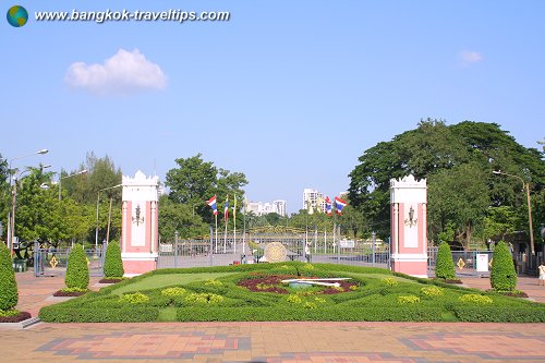
 Lumphini Park (22 October 2006)
Lumphini Park is the first and largest public park in Bangkok. Also written as Suan Lumphini, this 140-acre park is a gift of King Rama VI to the people and was created out of royal land in 1925, 15 years after he ascended the throne. His Majesty named the park after the birthplace of the Buddha in Nepal.
The site of Lumphini Park was initially intended to host a trade fair exhibiting local products and natural resources. It was mooted in an attempt to jumpstart the Siamese economy which has gone into recession following World War I. The site is crown property known as the Sala Daeng Fields. It was parcelled out for the construction of Chulalongkorn University and the Royal Bangkok Sports Club. Unfortunately, the fair never materialize because King Rama VI suddenly passed away.
Later on, his successor King Rama VII revived the idea for the park. To finance its maintenance, a 14.40 hectare plot was rented out to create an amusement park, called Vanaruengrom. Lumphini Park became a popular recreational space for the public. When giving the land to the government, King Rama VII decreed that it can only be used as a public park. It was so used, except during World War II, when Japanese soldiers occupied it as an army camp.
Today Lumphini Park is a popular place for the people of Bangkok to enjoy a spot of greenery within the otherwise concrete jungle. At its main entrance, which faces the corner of Ratchadamri Road and Thanon Rama IV (Rama IV Road), is the statue of King Rama VI.
Getting there
The MRT Si Lom (SIL) Station is the closest to Lumphini Park. The next nearest is the Sala Daeng (S2) BTS Station of the Skytrain Silom Line.Nearby Sights
- Chulalongkorn University
- Patpong
List of Parks in Bangkok; list of Districts of Bangkok
 Latest updates on Penang Travel Tips
 Map of Roads in Penang
Looking for information on Penang? Use this Map of Roads in Penang to zoom in on information about Penang, brought to you road by road.
Copyright © 2003-2025 Timothy Tye. All Rights Reserved.

 Go Back