 Santa Rosa and San Jacinta Mountains National Monument, California
Source: https://commons.wikimedia.org/wiki/File:Santa_Rosa_and_San_Jacinto_Mountains_283.jpg
Author: Geographer

Santa Rosa and San Jacinto Mountains National Monument is a protected nature site in Riverside County, California. Covering 272,000 acres (1,100 sq km), it includes parts of the Santa Rosa and San Jacinto ranges.
The national monument is home to a number of threatened and endangered wildlife, including the Peninsular Bighorn Sheep, which is endemic to the area. In addition, there are sites of cultural interest of the Native Americans within the area as well. They are mostly within land managed by the Agua Caliente Band of Cahuilla Indians.
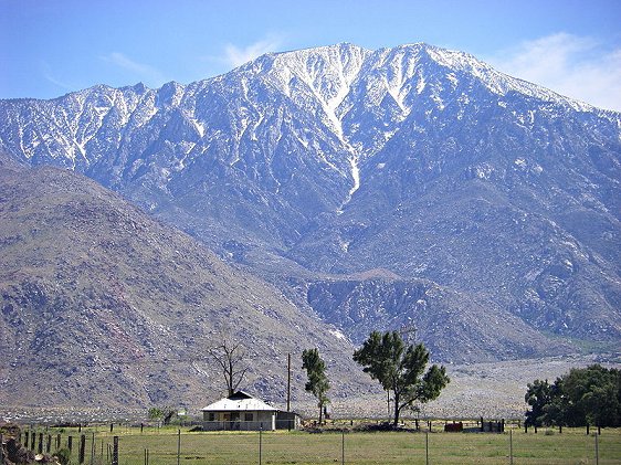 Mount San Jacinto
Source: https://commons.wikimedia.org/wiki/File:Mt_San_Jacinto_from_North.jpg
Author: Wattewyl

The Santa Rosa and San Jacinto Mountains National Monument exhibits a huge range of climatic variation, brought on by the great differences in elevation, which in turn affects the temperature and moisture of different parts of the site. The elevation ranges from below sea level to nearly 11,000 feet (3,400 m), within a short distance, culminating with San Jacinto Peak, the highest point in the Peninsular Range Province.
Visiting Santa Rosa and San Jacinto Mountains National Monument, California
The site is located to the east of Los Angeles. From LA, take the San Bernardino Freeway (aka Interstate 10). Turn off the highway at Exit 126 and head south on Date Palm Drive through Cathedral City till it joins State Route 111. Turn left and head east on 111 till Palm Desert. Turn right to State Route 74 (Pines to Palms Highway) and follow it till you arrive at the visitor center on your left. The site is jointly managed by the US Forest Service and the US Bureau of Land Management. Latest updates on Penang Travel Tips

Buy Me A Coffee
If you enjoy the information I provide and want to support the work I do, please buy me a coffee! I appreciate it immensely, thank you so much!

 Backtrack | HOME | Latest Updates |
Copyright © 2003-2026 Timothy Tye. All Rights Reserved.