 Stilt village along the coast of Palawan, Philippines
 http://commons.wikimedia.org/wiki/File:Palawan_-_Haven.jpg
 Torox
Torox
Palawan is the name of the island as well as the administrative province in southwestern Philippines. It is the largest province in the country. The main island of Palawan is a long but narrow island, measuring 450 kilometers (280 mi) from end to end and with a width of 50 km (31 mi) at the most. It has a jagged coastline dotted with coves and sea caves.
Palawan is sparsely populated compared to the other main islands of the Philippines. The island is still densely forested. The highest peak is Mount Mantalingahan, which is 2,086 m (6,843 ft). In addition to the main island, the province of Palawan also include the Calamianes group of islands.
 Seaside in Palawan
 http://commons.wikimedia.org/wiki/File:Palawan_-_Tropical_Hut.jpg
 Torox
Torox
Human habitan on Palawan Island goes back 22,000 years ago, as evidenced by the discovery of the remains of Tabon Man in 1962. It is the second oldest human remains to be found in the Philippines after that of the Callao Man, in Cagayan, in 2007, which is 67,000 years old.
In the pre-colonial times, Palawan was inhabited by various native tribes that migrated within the Malay archipelago. Chinese traders also visited the island as early as AD 982. Settlers of Malay stock arrived in the 12th century, establishing Malay chiefdoms. In the 13th century the Majapahit Empire extended its influence over the area, introducing Buddhism and Hinduism which however did not make a lasting impact on the population.
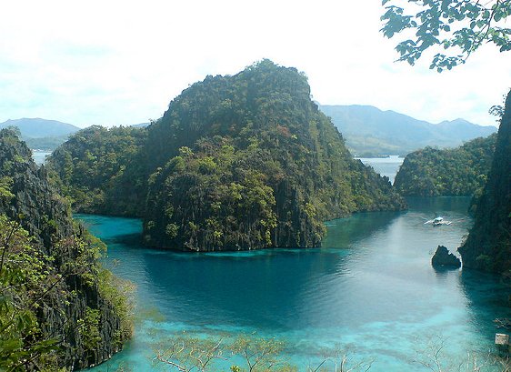
 Coron Island cove, Palawan
 http://commons.wikimedia.org/wiki/File:POTW_MichelleELLA01.jpg
 IRRI Images
The first Europeans to arrive in Palawan are believed to the the remaining crew of Ferdinand Magellan's voyage, after Magellan was killed in a fight in Cebu. One of the survivors, Antonio Pigafetta, who was Magellan's chronicler, called Palawan the Land of Promise because they found food there which saved them from starvation.
Spanish colonialization of Palawan began from north down, beginning with the Calamianes Islands. In the 17th century, Catholic missions were dispatched to various settlements in Palawan. In 1749 thewhole island was ceded by the Sultanate of Borneo to Spain.
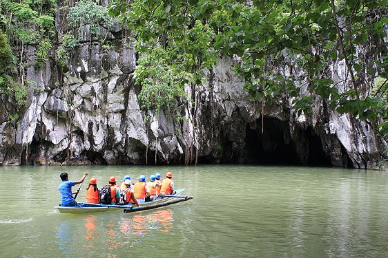
 Approaching Puerto Princesa Subterranean River
 http://en.wikipedia.org/wiki/File:Puerto_Princesa_Underground_River.jpg
 Mike Gonzalez
Main cities and municipalities of Palawan
- Puerto Princesa
Provincial capital of Palawan and its only city. It is also the second largest city in the Philippines, after Davao City, in area. - Brooke's Point
Town named after Sir James Brooke, the White Rajah of Sarawak, where the biggest pearl in the world was found. - Busuanga
Town on Busuanga Island, of the Calamian Group of Islands. - Coron
Town on Coron Island, part of the Calamian Group of Islands, popular as a diving location. - El Nido
Town on the northern tip of Palawan, famous for its limestone cliffs, lagoons and beautiful beaches.
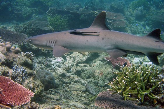
 Shark at Tubbataha Reef, Palawan, Philippines
 http://en.wikipedia.org/wiki/File:Tubbataha_Shark.jpg
 Simon Hefti
Places of Interest in Palawan
- San Vicente
Town in northwestern Palawan with the longest beach in the world. - Tubbataha Reef
Protected atoll coral reef in the Sulu Sea.
World Heritage Site in Palawan
- Puerto Princesa Subterranean River National Park
A nature site located some 50 km to the north of Puerto Princesa.
 Latest updates on Penang Travel Tips
 Discover with Timothy YouTube Channel
 PG Food Channel
 Learn Penang Hokkien YouTube Channel
 SojiMart Videos
 Share your travels and/or ask a travel-related question
Join the Penang Travel Tips Facebook Group to share photos, tips and anything related to your travels, or ask travel-related questions.
 Map of Roads in Penang
Looking for information on Penang? Use this Map of Roads in Penang to zoom in on information about Penang, brought to you road by road. Discover with Timothy
Let me take you to explore and discover Penang through my series of walking tours on YouTube. You may use these videos as your virtual tour guide. At the beginning of each video, I provide the starting point coordinates which you may key into your GPS, Google Maps or Waze, to be navigated to where I start the walk, and use the video as your virtual tour guide.Disclaimer
Please use the information on this page as guidance only. The author endeavours to update the information on this page from time to time, but regrets any inaccuracies if there be any.Latest from Discover with Timothy: Gurney Bay - what to see and do there
About this website

Hello and thanks for reading this page. My name is Timothy and my hobby is in describing places so that I can share the information with the general public. My website has become the go to site for a lot of people including students, teachers, journalists, etc. whenever they seek information on places, particularly those in Malaysia and Singapore. I have been doing this since 5 January 2003, for over twenty years already. You can read about me at Discover Timothy. By now I have compiled information on thousands of places, mostly in Peninsular Malaysia and Singapore, and I continue to add more almost every day. My goal is to describe every street in every town in Malaysia and Singapore.
Robbie's Roadmap
- Episode 1: Robbie's Journey to Financial Freedom
- Episode 2: Lost in America
- Episode 3: The Value of Money
- Episode 4: The Mentor
- Episode 5: The Thing that Makes Money
- Episode 6: The walk with a Billionaire
- Episode 7: The Financial Freedom Awakening
- Episode 8: Meet Mr Washington
- Episode 9: The Pizzeria Incident
Copyright © 2003-2024 Timothy Tye. All Rights Reserved.


 Go Back