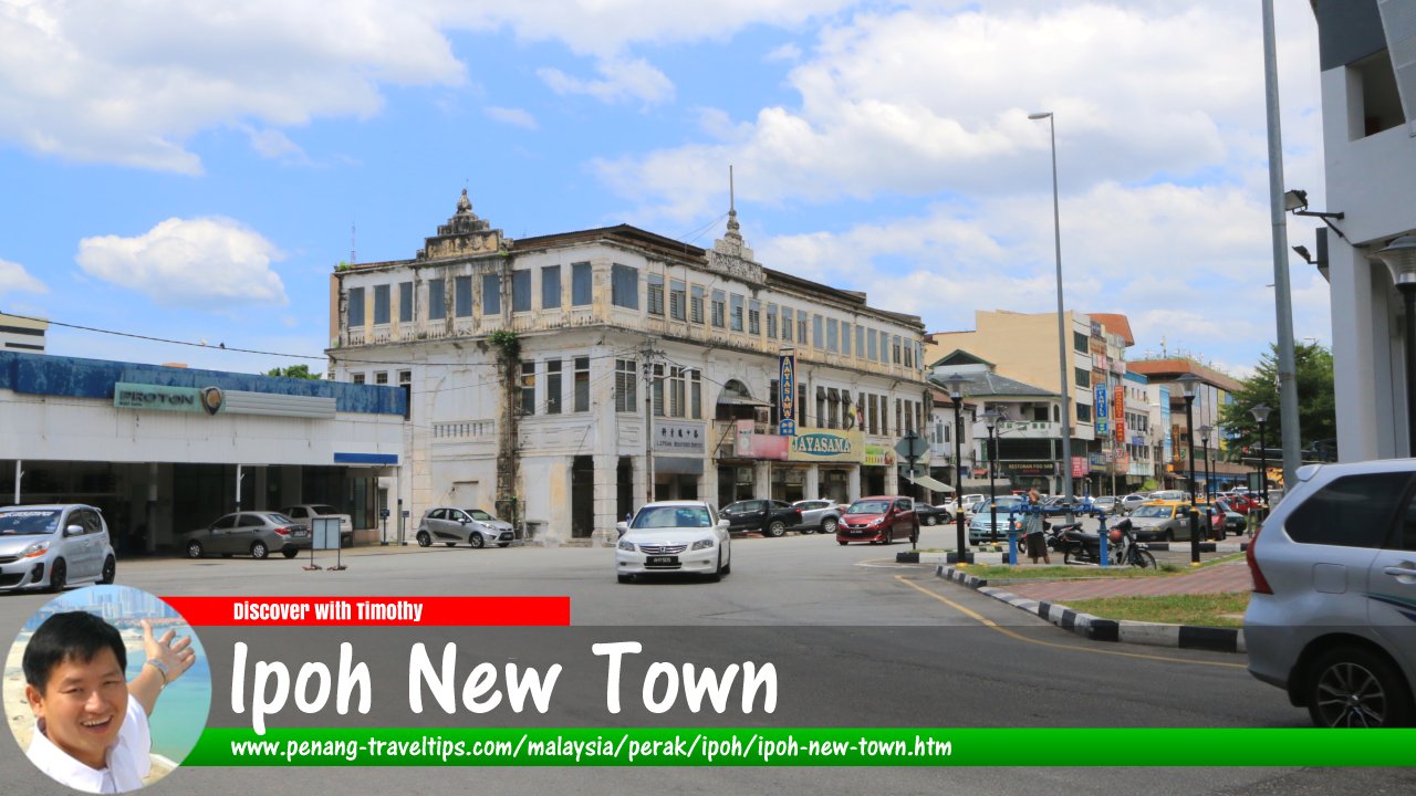
 Ipoh New Town (10 March 2018)
Ipoh New Town is the section of Ipoh on the eastern bank of the Kinta River. The development of Ipoh New Town began around 1907. Although that is a long, long time ago, but it is still "newer" than Ipoh Old Town, which was established in the third quarter of the 19th century. Both are now the older parts of Ipoh, as the City of Ipoh today encompasses a much larger area. Ipoh New Town overlaps with Taman Jubilee and is often used interchangeably.
Until the turn of the 20th century, Ipoh New Town was padi land, much of which belonging to the local nobleman, Dato Panglima Kinta Muhammad Yusuff. The Hugh Low Bridge was then a simple bridge that acted as the sole artery to the "outskirts". The transformation of rice fields to urban landscape was largely the work of local tycoon Yau Tet Shin, a good buddy of then Resident of Perak, Sir Ernest Woodford Birch.
To make the land east of the Kinta River attractive to new settlers, Yau Tet Shin erected a Chinese theatre there. A makeshift market which was already established there would one day become the Ipoh Central Market, known today as UTC Perak. Around these, Yau Tet Shin laid new roads in simple grid. At that time, cars were a novelty. Nonetheless Yau had the foresight to make the roads wide enough for them. As was expected, New Town became boom town, necessitating a widening of Huge Low Bridge.
Map of Ipoh New Town
Places of Interest and Heritage Sites in Ipoh New Town
- Birch Bridge (GPS: 6.435766, 100.190755)

- Chua Cheng Bok Building (GPS: 4.59438, 101.08022)

- Dato Seri Adika Raja House (GPS: 4.58992, 101.07921)

- Foong Seong Building (GPS: 4.59578, 101.0811)

- Hong Leong Bank Building (GPS: 4.59723, 101.08186)

- Hugh Low Bridge (GPS: 4.59438, 101.08022)

- Japanese Counter Espionage Headquarters (GPS: 4.59942, 101.08599)

- Masjid Paloh (GPS: 4.58986, 101.07721)

- Kompleks Yik Foong (GPS: 4.59708, 101.08134)

- Kuan Yin Temple (GPS: 4.59851, 101.07943)

- Majuperak Building (GPS: 4.59757, 101.0808)

- Masjid Panglima Kinta (GPS: 4.59342, 101.08063)

- McDonalds Ipoh (GPS: 4.59567, 101.08305)

- Public Bank Building (GPS: 4.59764, 101.08204)

- Sew Cheong Building (GPS: 4.59491, 101.08107)

- St Michael's Church (GPS: 4.59508, 101.08827)

- Wan Muhammad Saleh Mausoleum (GPS: 4.58996, 101.07676)

- Warta Kinta Office (GPS: 4.58976, 101.07766)

- UTC Perak (GPS: 4.59578, 101.08219)

Back to Discover Ipoh, Perak
 New Properties in Ipoh
Looking to buy a property in Ipoh? Get the e-brochures without having to visit different developers.- Bandar Baru Setia Awan Perdana E-Brochure
- E-Commerce Business Commune @ Menglembu E-Brochure
- Goshen @ Ipoh Premier City E-Brochure
- Jelapang Square Shops E-Brochure
- Manor Born E-Brochure
- Meru Aria E-Brochure
- Meru Desa Park E-Brochure
- Palazzo @ Ipoh Garden East E-Brochure
- Scientex Meru Heights Residences E-Brochure
- Soong Choon Business Centre E-Brochure
- Stallionz E-Brochure
- Station 18 E-Brochure
- The Anderson @ Ipoh E-Brochure
 Latest updates on Penang Travel Tips
 Discover with Timothy YouTube Channel
 PG Food Channel
 Learn Penang Hokkien YouTube Channel
 SojiMart Videos
 Discover with Timothy Ipoh Videos
Where to go, what to see when in Ipoh? Here are some suggestions with my videos! Ipoh Sight Index
Map of Ipoh, Perak
Latest from Discover with Timothy: Gurney Bay - what to see and do there
About this website

Hello and thanks for reading this page. My name is Timothy and my hobby is in describing places so that I can share the information with the general public. My website has become the go to site for a lot of people including students, teachers, journalists, etc. whenever they seek information on places, particularly those in Malaysia and Singapore. I have been doing this since 5 January 2003, for over twenty years already. You can read about me at Discover Timothy. By now I have compiled information on thousands of places, mostly in Peninsular Malaysia and Singapore, and I continue to add more almost every day. My goal is to describe every street in every town in Malaysia and Singapore.
Robbie's Roadmap
- Episode 1: Robbie's Journey to Financial Freedom
- Episode 2: Lost in America
- Episode 3: The Value of Money
- Episode 4: The Mentor
- Episode 5: The Thing that Makes Money
- Episode 6: The walk with a Billionaire
- Episode 7: The Financial Freedom Awakening
- Episode 8: Meet Mr Washington
- Episode 9: The Pizzeria Incident
Copyright © 2003-2024 Timothy Tye. All Rights Reserved.


 Go Back