
Broadway
 Go Back - Latest New York City > USA > Americas > World | YouTube : Facebook | About Me : Contact Me
In the beginning, Broadway was a Native American trail called the Wickquasgeck Trail. The trail originally snaked through swamps and rocks along the length of Manhattan Island. When the Dutch arrived, the trail became a main road through the island. It was first mentioned, by Dutch explorer and entrepreneur David de Vries, in 1642. At first, the Dutch called it "Heerestraat". In the 18th century Broadway ended north of Wall Street, where Eastern Post Road continued through the East Side of Manhattan while Bloomingdale Road on the west side. By the late 19th century, Bloomingdale Road north of Columbus Circle was widened and paved, and was called "The Boulevard". By the end of the century, however, the whole old road was renamed to Broadway.
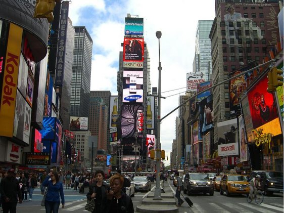
 Broadway at Times Square
Source: https://commons.wikimedia.org/wiki/File:4.29.11TimesSquareByLuigiNovi1.jpg
Author: Nightscream/Luigi Novi

Broadway runs the entire length of Manhattan Island, from Bowling Green at the south, to Inwood at the northern tip of the island. It is a one-way southbound street south of Columbus Circle, through traffic is blocked at Times Square from crossing Seventh Avenue directly. Broadway crosses Spuyten Duyvil Creek via the Broadway Bridge and continues through Marble Hill (a discontinuous portion of borough of Manhattan) and the Bronx into Westchester County. US 9 continues to be known as Broadway through its junction with NY 117.
Broadway cuts diagonally across the Commissioners' Plan of 1811 of Manhattan streets. Its intersections with avenues have been marked by "squares" - many just triangular slivers of open space, and resulted in some interesting architecture, such as the famous Flatiron Building.
New York City's ticker-tape parade is head on the section of lower Broadway from its origin at Bowling Green to City Hall Park. This section is often called the "Canyon of Heroes". West of Broadway as far as Canal Street was the city's fashionable residential area until circa 1825. Land reclamation has increased the size of this area threefold. The Hudson shore is now far to the west, beyond TriBeCa and Battery Park City.
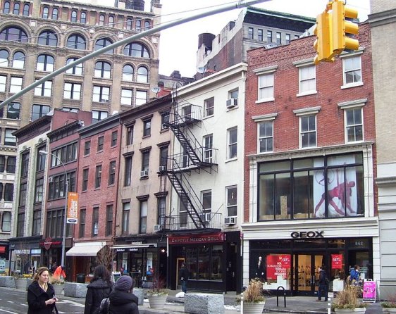
 Broadway between East 17th and 18th Streets
Source: https://commons.wikimedia.org/wiki/File:862-872_Broadway.jpg
Author: Beyond My Ken

Broadway marks the east boundary of Greenwich Village. It is a short walk from there to New York University near Washington Square Park, at the foot of Fifth Avenue. A bend in front of Grace Church was due to the road avoiding an earlier tavern that stood there.
At Union Square, Broadway continues its diagonal course across Manhattan, crossing 14th Street. At Madison Square, Broadway crosses Fifth Avenue at 23rd Street. At Herald Square, Broadway crosses Sixth Avenue (also called the Avenue of the Americas). Macy's Department Store is located on the western corner of Herald Square.
The stretch of Broadway near Times Square, where it crosses Seventh Avenue in midtown Manhattan, is the home of many Broadway theatres, housing an ever-changing array of commercial, large-scale plays, particularly musicals. This area of Manhattan is often called the Theater District or the Great White Way, - the nickname originates from a 1902 headline "Found on the Great White Way" in the New York Evening Telegram. This nickname was inspired by the millions of lights on theater marquees and billboard advertisements that illuminate the area.
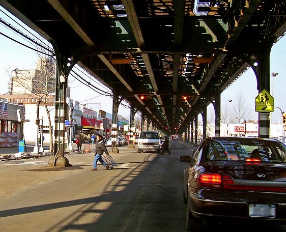
 View of Broadway in the Bronx, with the tracks of the 1 train overhead
Source: https://commons.wikimedia.org/wiki/File:Broadway_under_1_subway.jpg
Author: Daniel Case

At the southwest corner of Central Park, Broadway crosses Eighth Avenue at West 59th Street at Columbus Circle. Columbus Circle was one-time home of a convention center and now home of a new shopping center. North of Columbus Circle, Broadway retains planted center islands.
At the intersection of Columbus Avenue and West 65th Street, Broadway passes by the Juilliard School and Lincoln Center, both well-known performing arts landmarks, as well as a temple of The Church of Jesus Christ of Latter-day Saints, the Mormon or LDS Church.
At its intersection with 79th Street, Broadway makes a bend and then continues directly uptown aligned with the grid of the Commissioners' Plan of 1811. At the bend are The Apthorp and the First Baptist Church in the City of New York, an historic sanctuary built in 1891.
Further north, Broadway follows the old Bloomingdale Road as the main spine of the Upper West Side, passing the campus of Columbia University at 116th Street in Morningside Heights and CUNY - City College in Harlem as it continues northwards. New York-Presbyterian Hospital lies on Broadway near 166th, 167th, and 168th Streets in Washington Heights. At this point, Broadway becomes part of US 9.
 Latest updates on Penang Travel Tips
 Discover with Timothy YouTube Channel
 PG Food Channel
 Learn Penang Hokkien YouTube Channel
 SojiMart Videos
Latest from Discover with Timothy: Gurney Bay - what to see and do there
About this website

Hello and thanks for reading this page. My name is Timothy and my hobby is in describing places so that I can share the information with the general public. My website has become the go to site for a lot of people including students, teachers, journalists, etc. whenever they seek information on places, particularly those in Malaysia and Singapore. I have been doing this since 5 January 2003, for over twenty years already. You can read about me at Discover Timothy. By now I have compiled information on thousands of places, mostly in Peninsular Malaysia and Singapore, and I continue to add more almost every day. My goal is to describe every street in every town in Malaysia and Singapore.
Robbie's Roadmap
- Episode 1: Robbie's Journey to Financial Freedom
- Episode 2: Lost in America
- Episode 3: The Value of Money
- Episode 4: The Mentor
- Episode 5: The Thing that Makes Money
- Episode 6: The walk with a Billionaire
- Episode 7: The Financial Freedom Awakening
- Episode 8: Meet Mr Washington
- Episode 9: The Pizzeria Incident
Copyright © 2003-2024 Timothy Tye. All Rights Reserved.